You are here: Home > Network List > UU - University of Utah Regional Network Stations List
> Station CCUT Cedar City, UT, USA > Earthquake Result Viewer
CCUT Cedar City, UT, USA - Earthquake Result Viewer
| Earthquake location: |
Mendoza Province, Argentina |
| Earthquake latitude/longitude: |
-32.7/-67.1 |
| Earthquake time(UTC): |
2015/02/02 (033) 10:49:48 GMT |
| Earthquake Depth: |
172 km |
| Earthquake Magnitude: |
6.3 MO |
| Earthquake Catalog/Contributor: |
NEIC PDE/NEIC ALERT |
|
| Network: |
UU University of Utah Regional Network |
| Station: |
CCUT Cedar City, UT, USA |
| Lat/Lon: |
37.55 N/113.36 W |
| Elevation: |
2127 m |
|
| Distance: |
82.2 deg |
| Az: |
324.546 deg |
| Baz: |
142.031 deg |
| Ray Param: |
0.046673108 |
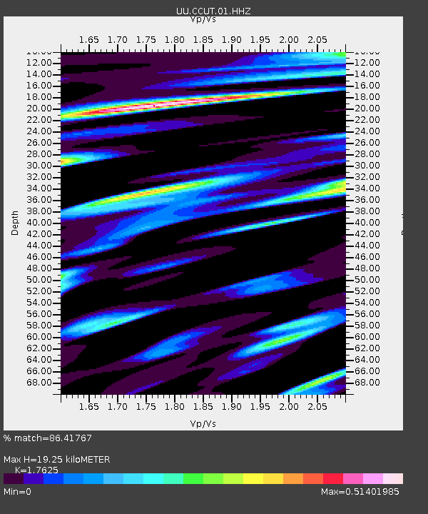
| Estimated Moho Depth: |
19.25 km |
| Estimated Crust Vp/Vs: |
1.76 |
| Assumed Crust Vp: |
6.194 km/s |
| Estimated Crust Vs: |
3.514 km/s |
| Estimated Crust Poisson's Ratio: |
0.26 |
|
| Radial Match: |
86.41767 % |
| Radial Bump: |
320 |
| Transverse Match: |
65.58716 % |
| Transverse Bump: |
400 |
| SOD ConfigId: |
837871 |
| Insert Time: |
2015-02-16 11:18:14.464 +0000 |
| GWidth: |
2.5 |
| Max Bumps: |
400 |
| Tol: |
0.001 |
|

Signal To Noise
| Channel | StoN | STA | LTA |
| UU:CCUT:01:HHZ:20150202T11:01:19.088977Z | 27.675463 | 2.618561E-6 | 9.46167E-8 |
| UU:CCUT:01:HHN:20150202T11:01:19.088977Z | 3.0653992 | 6.265148E-7 | 2.0438279E-7 |
| UU:CCUT:01:HHE:20150202T11:01:19.088977Z | 3.4168694 | 5.969376E-7 | 1.7470308E-7 |
| Arrivals |
| Ps | 2.4 SECOND |
| PpPs | 8.4 SECOND |
| PsPs/PpSs | 11 SECOND |


