You are here: Home > Network List > IU - Global Seismograph Network (GSN - IRIS/USGS) Stations List
> Station MA2 Magadan, Russia > Earthquake Result Viewer
MA2 Magadan, Russia - Earthquake Result Viewer
| Earthquake location: |
Ceram Sea |
| Earthquake latitude/longitude: |
-2.1/124.9 |
| Earthquake time(UTC): |
1998/11/29 (333) 14:10:31 GMT |
| Earthquake Depth: |
33 km |
| Earthquake Magnitude: |
6.5 MB, 7.7 MS, 8.1 UNKNOWN, 7.8 MW |
| Earthquake Catalog/Contributor: |
WHDF/NEIC |
|
| Network: |
IU Global Seismograph Network (GSN - IRIS/USGS) |
| Station: |
MA2 Magadan, Russia |
| Lat/Lon: |
59.58 N/150.77 E |
| Elevation: |
339 m |
|
| Distance: |
64.7 deg |
| Az: |
14.218 deg |
| Baz: |
208.836 deg |
| Ray Param: |
0.05867548 |
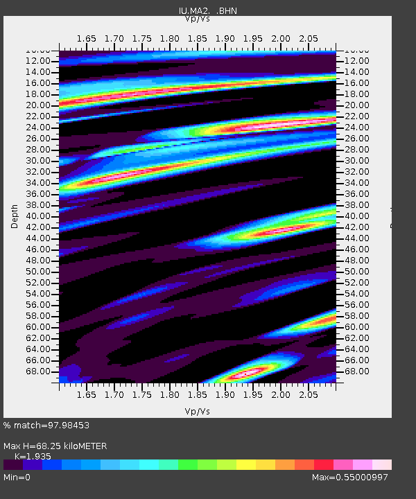
| Estimated Moho Depth: |
68.25 km |
| Estimated Crust Vp/Vs: |
1.93 |
| Assumed Crust Vp: |
6.134 km/s |
| Estimated Crust Vs: |
3.17 km/s |
| Estimated Crust Poisson's Ratio: |
0.32 |
|
| Radial Match: |
97.98453 % |
| Radial Bump: |
313 |
| Transverse Match: |
90.43949 % |
| Transverse Bump: |
400 |
| SOD ConfigId: |
4480 |
| Insert Time: |
2010-03-03 14:54:52.463 +0000 |
| GWidth: |
2.5 |
| Max Bumps: |
400 |
| Tol: |
0.001 |
|

Signal To Noise
| Channel | StoN | STA | LTA |
| IU:MA2: :BHN:19981129T14:20:36.115027Z | 8.61429 | 2.5762274E-6 | 2.990644E-7 |
| IU:MA2: :BHE:19981129T14:20:36.115027Z | 3.2282612 | 1.1162692E-6 | 3.4578036E-7 |
| IU:MA2: :BHZ:19981129T14:20:36.115027Z | 1.8626077 | 5.36276E-7 | 2.8791678E-7 |
| Arrivals |
| Ps | 11 SECOND |
| PpPs | 32 SECOND |
| PsPs/PpSs | 42 SECOND |


