You are here: Home > Network List > OK - Oklahoma Seismic Network Stations List
> Station CROK Carrier, Oklahoma > Earthquake Result Viewer
CROK Carrier, Oklahoma - Earthquake Result Viewer
| Earthquake location: |
Near Coast Of Central Chile |
| Earthquake latitude/longitude: |
-36.3/-73.8 |
| Earthquake time(UTC): |
2015/06/20 (171) 02:10:06 GMT |
| Earthquake Depth: |
10 km |
| Earthquake Magnitude: |
6.4 MO |
| Earthquake Catalog/Contributor: |
NEIC PDE/NEIC ALERT |
|
| Network: |
OK Oklahoma Seismic Network |
| Station: |
CROK Carrier, Oklahoma |
| Lat/Lon: |
36.50 N/97.98 W |
| Elevation: |
403 m |
|
| Distance: |
75.9 deg |
| Az: |
340.114 deg |
| Baz: |
160.067 deg |
| Ray Param: |
0.051382016 |
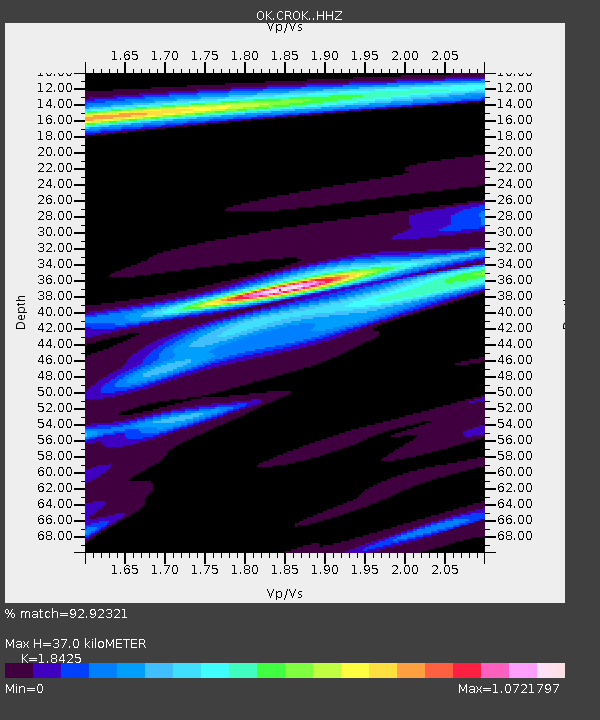
| Estimated Moho Depth: |
37.0 km |
| Estimated Crust Vp/Vs: |
1.84 |
| Assumed Crust Vp: |
6.483 km/s |
| Estimated Crust Vs: |
3.518 km/s |
| Estimated Crust Poisson's Ratio: |
0.29 |
|
| Radial Match: |
92.92321 % |
| Radial Bump: |
400 |
| Transverse Match: |
75.487236 % |
| Transverse Bump: |
400 |
| SOD ConfigId: |
7422571 |
| Insert Time: |
2019-04-19 09:49:28.917 +0000 |
| GWidth: |
2.5 |
| Max Bumps: |
400 |
| Tol: |
0.001 |
|

Signal To Noise
| Channel | StoN | STA | LTA |
| OK:CROK: :HHZ:20150620T02:21:21.848975Z | 4.3206615 | 3.0926148E-7 | 7.157735E-8 |
| OK:CROK: :HHN:20150620T02:21:21.848975Z | 1.716219 | 2.6616897E-7 | 1.5509033E-7 |
| OK:CROK: :HHE:20150620T02:21:21.848975Z | 1.0766879 | 1.061256E-7 | 9.856672E-8 |
| Arrivals |
| Ps | 5.0 SECOND |
| PpPs | 16 SECOND |
| PsPs/PpSs | 21 SECOND |


