You are here: Home > Network List > IU - Global Seismograph Network (GSN - IRIS/USGS) Stations List
> Station MA2 Magadan, Russia > Earthquake Result Viewer
MA2 Magadan, Russia - Earthquake Result Viewer

| Earthquake location: |
Sunda Strait, Indonesia |
| Earthquake latitude/longitude: |
-6.6/105.5 |
| Earthquake time(UTC): |
1997/03/17 (076) 08:05:48 GMT |
| Earthquake Depth: |
33 km |
| Earthquake Magnitude: |
5.8 MB, 6.2 MS, 6.4 UNKNOWN, 6.3 MW |
| Earthquake Catalog/Contributor: |
WHDF/NEIC |
|
| Network: |
IU Global Seismograph Network (GSN - IRIS/USGS) |
| Station: |
MA2 Magadan, Russia |
| Lat/Lon: |
59.58 N/150.77 E |
| Elevation: |
339 m |
|
| Distance: |
75.1 deg |
| Az: |
21.967 deg |
| Baz: |
226.903 deg |
| Ray Param: |
0.05185726 |
| Estimated Moho Depth: |
16.25 km |
| Estimated Crust Vp/Vs: |
1.77 |
| Assumed Crust Vp: |
6.134 km/s |
| Estimated Crust Vs: |
3.456 km/s |
| Estimated Crust Poisson's Ratio: |
0.27 |
|
| Radial Match: |
96.195984 % |
| Radial Bump: |
400 |
| Transverse Match: |
91.742836 % |
| Transverse Bump: |
400 |
| SOD ConfigId: |
4480 |
| Insert Time: |
2010-03-03 14:55:03.184 +0000 |
| GWidth: |
2.5 |
| Max Bumps: |
400 |
| Tol: |
0.001 |
|
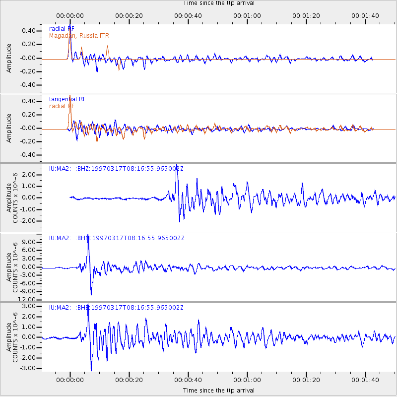
Signal To Noise
| Channel | StoN | STA | LTA |
| IU:MA2: :BHN:19970317T08:16:55.965002Z | 11.121741 | 5.7062704E-7 | 5.1307346E-8 |
| IU:MA2: :BHE:19970317T08:16:55.965002Z | 2.3142803 | 1.8941293E-7 | 8.184528E-8 |
| IU:MA2: :BHZ:19970317T08:16:55.965002Z | 4.2138734 | 2.0799025E-7 | 4.935845E-8 |
| Arrivals |
| Ps | 2.1 SECOND |
| PpPs | 7.1 SECOND |
| PsPs/PpSs | 9.3 SECOND |


