You are here: Home > Network List > UU - University of Utah Regional Network Stations List
> Station SZCU Shurtz Canyon, UT, USA > Earthquake Result Viewer
SZCU Shurtz Canyon, UT, USA - Earthquake Result Viewer
| Earthquake location: |
Mendoza Province, Argentina |
| Earthquake latitude/longitude: |
-32.7/-67.1 |
| Earthquake time(UTC): |
2015/02/02 (033) 10:49:48 GMT |
| Earthquake Depth: |
172 km |
| Earthquake Magnitude: |
6.3 MO |
| Earthquake Catalog/Contributor: |
NEIC PDE/NEIC ALERT |
|
| Network: |
UU University of Utah Regional Network |
| Station: |
SZCU Shurtz Canyon, UT, USA |
| Lat/Lon: |
37.60 N/113.09 W |
| Elevation: |
2026 m |
|
| Distance: |
82.1 deg |
| Az: |
324.748 deg |
| Baz: |
142.226 deg |
| Ray Param: |
0.046741188 |
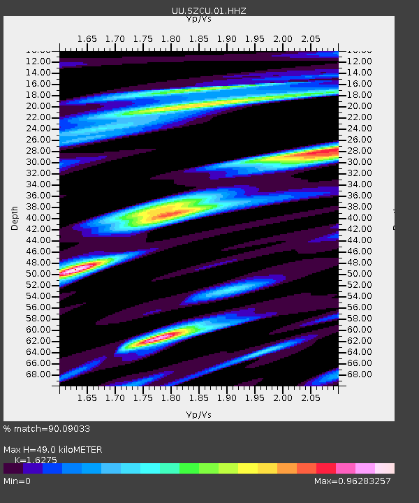
| Estimated Moho Depth: |
49.0 km |
| Estimated Crust Vp/Vs: |
1.63 |
| Assumed Crust Vp: |
6.194 km/s |
| Estimated Crust Vs: |
3.806 km/s |
| Estimated Crust Poisson's Ratio: |
0.20 |
|
| Radial Match: |
90.09033 % |
| Radial Bump: |
275 |
| Transverse Match: |
61.364174 % |
| Transverse Bump: |
293 |
| SOD ConfigId: |
837871 |
| Insert Time: |
2015-02-16 11:18:54.874 +0000 |
| GWidth: |
2.5 |
| Max Bumps: |
400 |
| Tol: |
0.001 |
|

Signal To Noise
| Channel | StoN | STA | LTA |
| UU:SZCU:01:HHZ:20150202T11:01:18.569995Z | 24.331287 | 6.335824E-8 | 2.6039824E-9 |
| UU:SZCU:01:HHN:20150202T11:01:18.569995Z | 5.1895943 | 1.7799845E-8 | 3.4299106E-9 |
| UU:SZCU:01:HHE:20150202T11:01:18.569995Z | 4.8701205 | 1.9757094E-8 | 4.0567976E-9 |
| Arrivals |
| Ps | 5.1 SECOND |
| PpPs | 20 SECOND |
| PsPs/PpSs | 25 SECOND |


