You are here: Home > Network List > TA - USArray Transportable Network (new EarthScope stations) Stations List
> Station E62A Clayton Lake, ME, USA > Earthquake Result Viewer
E62A Clayton Lake, ME, USA - Earthquake Result Viewer

| Earthquake location: |
Near Coast Of Central Chile |
| Earthquake latitude/longitude: |
-36.3/-73.8 |
| Earthquake time(UTC): |
2015/06/20 (171) 02:10:06 GMT |
| Earthquake Depth: |
10 km |
| Earthquake Magnitude: |
6.4 MO |
| Earthquake Catalog/Contributor: |
NEIC PDE/NEIC ALERT |
|
| Network: |
TA USArray Transportable Network (new EarthScope stations) |
| Station: |
E62A Clayton Lake, ME, USA |
| Lat/Lon: |
46.62 N/69.52 W |
| Elevation: |
356 m |
|
| Distance: |
82.7 deg |
| Az: |
2.983 deg |
| Baz: |
183.495 deg |
| Ray Param: |
0.046730623 |
| Estimated Moho Depth: |
37.0 km |
| Estimated Crust Vp/Vs: |
1.76 |
| Assumed Crust Vp: |
6.419 km/s |
| Estimated Crust Vs: |
3.652 km/s |
| Estimated Crust Poisson's Ratio: |
0.26 |
|
| Radial Match: |
94.20443 % |
| Radial Bump: |
400 |
| Transverse Match: |
82.31266 % |
| Transverse Bump: |
400 |
| SOD ConfigId: |
7422571 |
| Insert Time: |
2019-04-19 09:50:44.496 +0000 |
| GWidth: |
2.5 |
| Max Bumps: |
400 |
| Tol: |
0.001 |
|
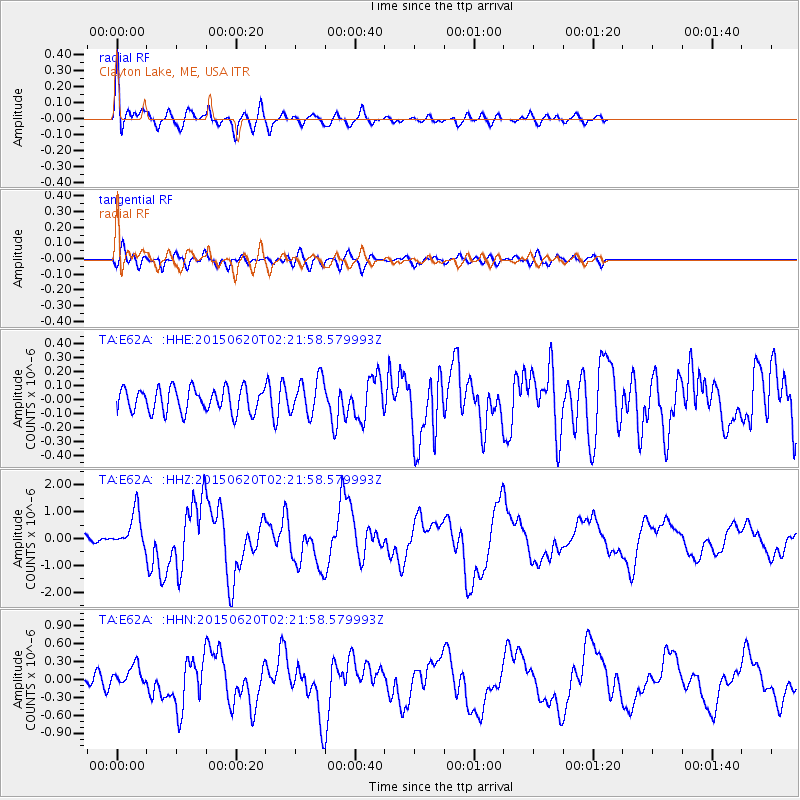
Signal To Noise
| Channel | StoN | STA | LTA |
| TA:E62A: :HHZ:20150620T02:21:58.579993Z | 6.515602 | 6.767055E-7 | 1.0385924E-7 |
| TA:E62A: :HHN:20150620T02:21:58.579993Z | 3.2512043 | 1.7158256E-7 | 5.277508E-8 |
| TA:E62A: :HHE:20150620T02:21:58.579993Z | 1.4928823 | 1.2823092E-7 | 8.5894875E-8 |
| Arrivals |
| Ps | 4.5 SECOND |
| PpPs | 15 SECOND |
| PsPs/PpSs | 20 SECOND |


