You are here: Home > Network List > TA - USArray Transportable Network (new EarthScope stations) Stations List
> Station H64A Troy, ME, USA > Earthquake Result Viewer
H64A Troy, ME, USA - Earthquake Result Viewer
| Earthquake location: |
Near Coast Of Central Chile |
| Earthquake latitude/longitude: |
-36.3/-73.8 |
| Earthquake time(UTC): |
2015/06/20 (171) 02:10:06 GMT |
| Earthquake Depth: |
10 km |
| Earthquake Magnitude: |
6.4 MO |
| Earthquake Catalog/Contributor: |
NEIC PDE/NEIC ALERT |
|
| Network: |
TA USArray Transportable Network (new EarthScope stations) |
| Station: |
H64A Troy, ME, USA |
| Lat/Lon: |
44.64 N/69.22 W |
| Elevation: |
158 m |
|
| Distance: |
80.7 deg |
| Az: |
3.323 deg |
| Baz: |
183.76 deg |
| Ray Param: |
0.04809735 |
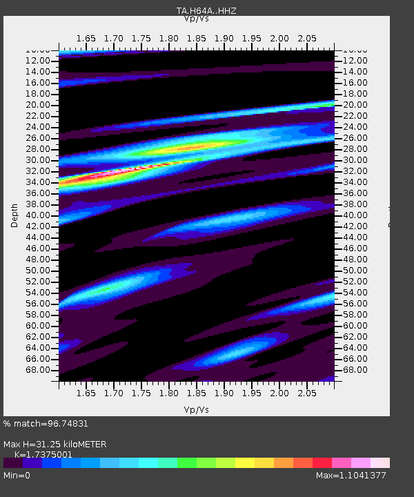
| Estimated Moho Depth: |
31.25 km |
| Estimated Crust Vp/Vs: |
1.74 |
| Assumed Crust Vp: |
6.419 km/s |
| Estimated Crust Vs: |
3.695 km/s |
| Estimated Crust Poisson's Ratio: |
0.25 |
|
| Radial Match: |
96.74831 % |
| Radial Bump: |
305 |
| Transverse Match: |
76.25358 % |
| Transverse Bump: |
400 |
| SOD ConfigId: |
7422571 |
| Insert Time: |
2019-04-19 09:51:06.781 +0000 |
| GWidth: |
2.5 |
| Max Bumps: |
400 |
| Tol: |
0.001 |
|

Signal To Noise
| Channel | StoN | STA | LTA |
| TA:H64A: :HHZ:20150620T02:21:48.259985Z | 7.1729097 | 6.3227026E-7 | 8.814697E-8 |
| TA:H64A: :HHN:20150620T02:21:48.259985Z | 3.278324 | 2.3739348E-7 | 7.241306E-8 |
| TA:H64A: :HHE:20150620T02:21:48.259985Z | 1.1276215 | 6.2898586E-8 | 5.5779868E-8 |
| Arrivals |
| Ps | 3.7 SECOND |
| PpPs | 13 SECOND |
| PsPs/PpSs | 17 SECOND |


