You are here: Home > Network List > TA - USArray Transportable Network (new EarthScope stations) Stations List
> Station K61A Williamstown, MA, USA > Earthquake Result Viewer
K61A Williamstown, MA, USA - Earthquake Result Viewer
| Earthquake location: |
Near Coast Of Central Chile |
| Earthquake latitude/longitude: |
-36.3/-73.8 |
| Earthquake time(UTC): |
2015/06/20 (171) 02:10:06 GMT |
| Earthquake Depth: |
10 km |
| Earthquake Magnitude: |
6.4 MO |
| Earthquake Catalog/Contributor: |
NEIC PDE/NEIC ALERT |
|
| Network: |
TA USArray Transportable Network (new EarthScope stations) |
| Station: |
K61A Williamstown, MA, USA |
| Lat/Lon: |
42.67 N/73.27 W |
| Elevation: |
391 m |
|
| Distance: |
78.6 deg |
| Az: |
0.413 deg |
| Baz: |
180.452 deg |
| Ray Param: |
0.0495144 |
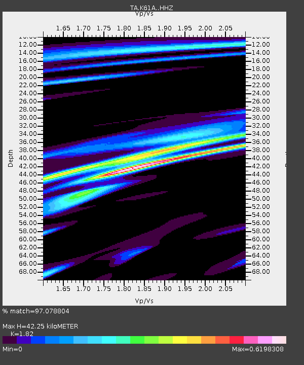
| Estimated Moho Depth: |
42.25 km |
| Estimated Crust Vp/Vs: |
1.82 |
| Assumed Crust Vp: |
6.419 km/s |
| Estimated Crust Vs: |
3.527 km/s |
| Estimated Crust Poisson's Ratio: |
0.28 |
|
| Radial Match: |
97.078804 % |
| Radial Bump: |
202 |
| Transverse Match: |
84.00559 % |
| Transverse Bump: |
400 |
| SOD ConfigId: |
7422571 |
| Insert Time: |
2019-04-19 09:51:24.614 +0000 |
| GWidth: |
2.5 |
| Max Bumps: |
400 |
| Tol: |
0.001 |
|

Signal To Noise
| Channel | StoN | STA | LTA |
| TA:K61A: :HHZ:20150620T02:21:37.059973Z | 8.452363 | 5.550281E-7 | 6.566544E-8 |
| TA:K61A: :HHN:20150620T02:21:37.059973Z | 4.218084 | 2.3008002E-7 | 5.45461E-8 |
| TA:K61A: :HHE:20150620T02:21:37.059973Z | 1.4190999 | 8.027532E-8 | 5.6567767E-8 |
| Arrivals |
| Ps | 5.6 SECOND |
| PpPs | 18 SECOND |
| PsPs/PpSs | 24 SECOND |


