You are here: Home > Network List > TA - USArray Transportable Network (new EarthScope stations) Stations List
> Station L64A Middleborough, MA, USA > Earthquake Result Viewer
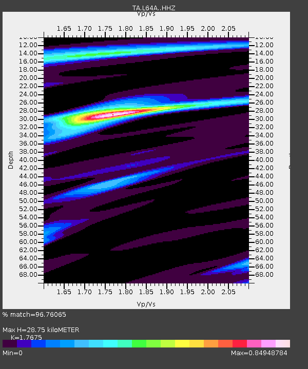
L64A Middleborough, MA, USA - Earthquake Result Viewer
| Earthquake location: |
Near Coast Of Central Chile |
| Earthquake latitude/longitude: |
-36.3/-73.8 |
| Earthquake time(UTC): |
2015/06/20 (171) 02:10:06 GMT |
| Earthquake Depth: |
10 km |
| Earthquake Magnitude: |
6.4 MO |
| Earthquake Catalog/Contributor: |
NEIC PDE/NEIC ALERT |
|
| Network: |
TA USArray Transportable Network (new EarthScope stations) |
| Station: |
L64A Middleborough, MA, USA |
| Lat/Lon: |
41.94 N/70.84 W |
| Elevation: |
17 m |
|
| Distance: |
77.9 deg |
| Az: |
2.271 deg |
| Baz: |
182.458 deg |
| Ray Param: |
0.049982287 |
| Estimated Moho Depth: |
28.75 km |
| Estimated Crust Vp/Vs: |
1.77 |
| Assumed Crust Vp: |
6.472 km/s |
| Estimated Crust Vs: |
3.662 km/s |
| Estimated Crust Poisson's Ratio: |
0.26 |
|
| Radial Match: |
96.76065 % |
| Radial Bump: |
286 |
| Transverse Match: |
80.87999 % |
| Transverse Bump: |
400 |
| SOD ConfigId: |
7422571 |
| Insert Time: |
2019-04-19 09:51:31.414 +0000 |
| GWidth: |
2.5 |
| Max Bumps: |
400 |
| Tol: |
0.001 |
|

Signal To Noise
| Channel | StoN | STA | LTA |
| TA:L64A: :HHZ:20150620T02:21:33.249976Z | 7.55812 | 5.9634965E-7 | 7.8901856E-8 |
| TA:L64A: :HHN:20150620T02:21:33.249976Z | 4.137094 | 2.5730054E-7 | 6.219355E-8 |
| TA:L64A: :HHE:20150620T02:21:33.249976Z | 0.7233992 | 4.296216E-8 | 5.9389283E-8 |
| Arrivals |
| Ps | 3.5 SECOND |
| PpPs | 12 SECOND |
| PsPs/PpSs | 15 SECOND |


