You are here: Home > Network List > X812 - Deep Structure of Three Continental Sutures in Eastern North America Stations List
> Station QM28 6 mile checkpoint, Maine, USA > Earthquake Result Viewer
QM28 6 mile checkpoint, Maine, USA - Earthquake Result Viewer
| Earthquake location: |
Near Coast Of Central Chile |
| Earthquake latitude/longitude: |
-36.3/-73.8 |
| Earthquake time(UTC): |
2015/06/20 (171) 02:10:06 GMT |
| Earthquake Depth: |
10 km |
| Earthquake Magnitude: |
6.4 MO |
| Earthquake Catalog/Contributor: |
NEIC PDE/NEIC ALERT |
|
| Network: |
X8 Deep Structure of Three Continental Sutures in Eastern North America |
| Station: |
QM28 6 mile checkpoint, Maine, USA |
| Lat/Lon: |
46.64 N/68.53 W |
| Elevation: |
212 m |
|
| Distance: |
82.7 deg |
| Az: |
3.671 deg |
| Baz: |
184.303 deg |
| Ray Param: |
0.046687737 |
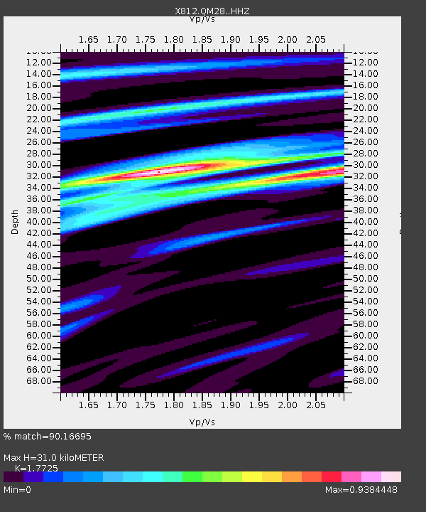
| Estimated Moho Depth: |
31.0 km |
| Estimated Crust Vp/Vs: |
1.77 |
| Assumed Crust Vp: |
6.419 km/s |
| Estimated Crust Vs: |
3.622 km/s |
| Estimated Crust Poisson's Ratio: |
0.27 |
|
| Radial Match: |
90.16695 % |
| Radial Bump: |
400 |
| Transverse Match: |
73.91769 % |
| Transverse Bump: |
400 |
| SOD ConfigId: |
7422571 |
| Insert Time: |
2019-04-19 09:53:16.509 +0000 |
| GWidth: |
2.5 |
| Max Bumps: |
400 |
| Tol: |
0.001 |
|

Signal To Noise
| Channel | StoN | STA | LTA |
| X8:QM28: :HHZ:20150620T02:21:58.884985Z | 4.035974 | 6.5043264E-7 | 1.6115877E-7 |
| X8:QM28: :HHN:20150620T02:21:58.884985Z | 2.0725956 | 2.9511028E-7 | 1.4238682E-7 |
| X8:QM28: :HHE:20150620T02:21:58.884985Z | 0.9427595 | 1.3689275E-7 | 1.4520433E-7 |
| Arrivals |
| Ps | 3.8 SECOND |
| PpPs | 13 SECOND |
| PsPs/PpSs | 17 SECOND |


