You are here: Home > Network List > IU - Global Seismograph Network (GSN - IRIS/USGS) Stations List
> Station MA2 Magadan, Russia > Earthquake Result Viewer
MA2 Magadan, Russia - Earthquake Result Viewer
| Earthquake location: |
Banda Sea |
| Earthquake latitude/longitude: |
-5.5/128.1 |
| Earthquake time(UTC): |
2006/01/27 (027) 16:58:53 GMT |
| Earthquake Depth: |
397 km |
| Earthquake Magnitude: |
7.0 MB, 7.6 MW, 7.5 MW |
| Earthquake Catalog/Contributor: |
WHDF/NEIC |
|
| Network: |
IU Global Seismograph Network (GSN - IRIS/USGS) |
| Station: |
MA2 Magadan, Russia |
| Lat/Lon: |
59.58 N/150.77 E |
| Elevation: |
339 m |
|
| Distance: |
67.3 deg |
| Az: |
12.261 deg |
| Baz: |
204.544 deg |
| Ray Param: |
0.055773813 |
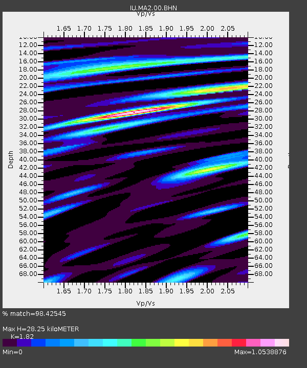
| Estimated Moho Depth: |
28.25 km |
| Estimated Crust Vp/Vs: |
1.82 |
| Assumed Crust Vp: |
6.134 km/s |
| Estimated Crust Vs: |
3.37 km/s |
| Estimated Crust Poisson's Ratio: |
0.28 |
|
| Radial Match: |
98.42545 % |
| Radial Bump: |
390 |
| Transverse Match: |
93.16645 % |
| Transverse Bump: |
400 |
| SOD ConfigId: |
4977 |
| Insert Time: |
2010-03-03 14:56:41.801 +0000 |
| GWidth: |
2.5 |
| Max Bumps: |
400 |
| Tol: |
0.001 |
|

Signal To Noise
| Channel | StoN | STA | LTA |
| IU:MA2:00:BHN:20060127T17:08:36.261003Z | 25.899971 | 1.07780015E-5 | 4.161395E-7 |
| IU:MA2:00:BHE:20060127T17:08:36.261003Z | 27.132156 | 4.7613653E-6 | 1.754879E-7 |
| IU:MA2:00:BHZ:20060127T17:08:36.261003Z | 44.863873 | 2.6205002E-5 | 5.841003E-7 |
| Arrivals |
| Ps | 3.9 SECOND |
| PpPs | 13 SECOND |
| PsPs/PpSs | 16 SECOND |


