You are here: Home > Network List > PF - Volcanologic Network of Piton de Fournaise-OVPF Stations List
> Station FRE Station Sismologique des Fonds de la Riviere de l'Est > Earthquake Result Viewer
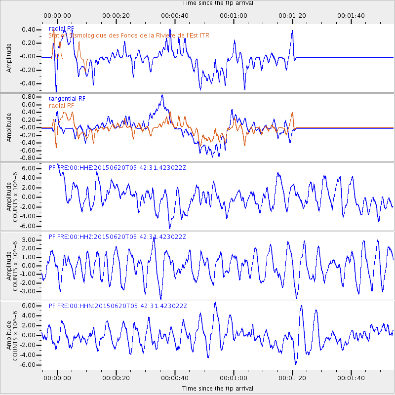
FRE Station Sismologique des Fonds de la Riviere de l'Est - Earthquake Result Viewer
*The percent match for this event was below the threshold and hence no stack was calculated.
| Earthquake location: |
South Sandwich Islands Region |
| Earthquake latitude/longitude: |
-59.6/-26.6 |
| Earthquake time(UTC): |
2015/06/20 (171) 05:32:16 GMT |
| Earthquake Depth: |
117 km |
| Earthquake Magnitude: |
5.6 MB |
| Earthquake Catalog/Contributor: |
NEIC PDE/NEIC ALERT |
|
| Network: |
PF Volcanologic Network of Piton de Fournaise-OVPF |
| Station: |
FRE Station Sismologique des Fonds de la Riviere de l'Est |
| Lat/Lon: |
21.20 S/55.70 E |
| Elevation: |
1775 m |
|
| Distance: |
68.1 deg |
| Az: |
94.648 deg |
| Baz: |
212.877 deg |
| Ray Param: |
$rayparam |
*The percent match for this event was below the threshold and hence was not used in the summary stack. |
|
| Radial Match: |
39.97495 % |
| Radial Bump: |
400 |
| Transverse Match: |
44.34441 % |
| Transverse Bump: |
400 |
| SOD ConfigId: |
7422571 |
| Insert Time: |
2019-04-19 10:03:01.301 +0000 |
| GWidth: |
2.5 |
| Max Bumps: |
400 |
| Tol: |
0.001 |
|
Signal To Noise
| Channel | StoN | STA | LTA |
| PF:FRE:00:HHZ:20150620T05:42:31.423022Z | 1.1598268 | 1.1336078E-6 | 9.773942E-7 |
| PF:FRE:00:HHN:20150620T05:42:31.423022Z | 0.9444275 | 1.8764256E-6 | 1.9868392E-6 |
| PF:FRE:00:HHE:20150620T05:42:31.423022Z | 1.3305727 | 2.6093421E-6 | 1.961067E-6 |
| Arrivals |
| Ps | |
| PpPs | |
| PsPs/PpSs | |


