You are here: Home > Network List > IU - Global Seismograph Network (GSN - IRIS/USGS) Stations List
> Station MA2 Magadan, Russia > Earthquake Result Viewer
MA2 Magadan, Russia - Earthquake Result Viewer
| Earthquake location: |
Sulawesi, Indonesia |
| Earthquake latitude/longitude: |
-1.1/123.6 |
| Earthquake time(UTC): |
2000/05/04 (125) 04:21:16 GMT |
| Earthquake Depth: |
26 km |
| Earthquake Magnitude: |
6.7 MB, 7.5 MS, 7.6 MW, 7.5 ME |
| Earthquake Catalog/Contributor: |
WHDF/NEIC |
|
| Network: |
IU Global Seismograph Network (GSN - IRIS/USGS) |
| Station: |
MA2 Magadan, Russia |
| Lat/Lon: |
59.58 N/150.77 E |
| Elevation: |
339 m |
|
| Distance: |
64.1 deg |
| Az: |
14.98 deg |
| Baz: |
210.517 deg |
| Ray Param: |
0.05907513 |
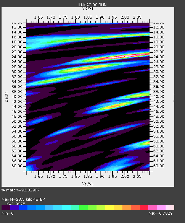
| Estimated Moho Depth: |
23.5 km |
| Estimated Crust Vp/Vs: |
2.00 |
| Assumed Crust Vp: |
6.134 km/s |
| Estimated Crust Vs: |
3.071 km/s |
| Estimated Crust Poisson's Ratio: |
0.33 |
|
| Radial Match: |
96.82997 % |
| Radial Bump: |
392 |
| Transverse Match: |
91.4473 % |
| Transverse Bump: |
400 |
| SOD ConfigId: |
3744 |
| Insert Time: |
2010-03-03 14:58:03.424 +0000 |
| GWidth: |
2.5 |
| Max Bumps: |
400 |
| Tol: |
0.001 |
|
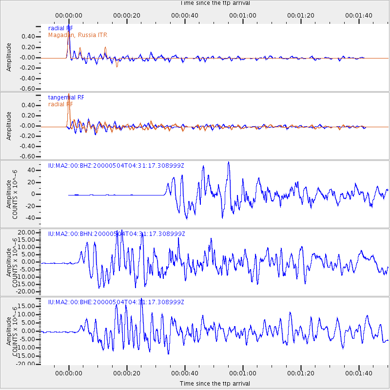
Signal To Noise
| Channel | StoN | STA | LTA |
| IU:MA2:00:BHN:20000504T04:31:17.308999Z | 19.816603 | 2.6286723E-6 | 1.3265E-7 |
| IU:MA2:00:BHE:20000504T04:31:17.308999Z | 7.951882 | 1.4278962E-6 | 1.7956708E-7 |
| IU:MA2:00:BHZ:20000504T04:31:17.308999Z | 47.595947 | 6.4399974E-6 | 1.3530558E-7 |
| Arrivals |
| Ps | 4.0 SECOND |
| PpPs | 11 SECOND |
| PsPs/PpSs | 15 SECOND |


