You are here: Home > Network List > AZ - ANZA Regional Network Stations List
> Station SMER AZ.SMER > Earthquake Result Viewer
SMER AZ.SMER - Earthquake Result Viewer
*The percent match for this event was below the threshold and hence no stack was calculated.
| Earthquake location: |
South Of Fiji Islands |
| Earthquake latitude/longitude: |
-23.6/-177.1 |
| Earthquake time(UTC): |
2015/06/20 (171) 23:39:09 GMT |
| Earthquake Depth: |
158 km |
| Earthquake Magnitude: |
5.9 MO |
| Earthquake Catalog/Contributor: |
NEIC PDE/NEIC ALERT |
|
| Network: |
AZ ANZA Regional Network |
| Station: |
SMER AZ.SMER |
| Lat/Lon: |
33.46 N/117.17 W |
| Elevation: |
355 m |
|
| Distance: |
80.4 deg |
| Az: |
47.196 deg |
| Baz: |
233.641 deg |
| Ray Param: |
$rayparam |
*The percent match for this event was below the threshold and hence was not used in the summary stack. |
|
| Radial Match: |
21.977898 % |
| Radial Bump: |
400 |
| Transverse Match: |
15.0892935 % |
| Transverse Bump: |
400 |
| SOD ConfigId: |
7422571 |
| Insert Time: |
2019-04-19 10:06:42.555 +0000 |
| GWidth: |
2.5 |
| Max Bumps: |
400 |
| Tol: |
0.001 |
|
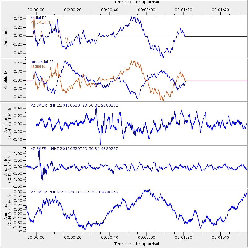
Signal To Noise
| Channel | StoN | STA | LTA |
| AZ:SMER: :HHZ:20150620T23:50:31.938025Z | 7.4064965 | 5.838388E-7 | 7.882793E-8 |
| AZ:SMER: :HHN:20150620T23:50:31.938025Z | 1.0187968 | 2.4277924E-7 | 2.3829995E-7 |
| AZ:SMER: :HHE:20150620T23:50:31.938025Z | 3.2358396 | 2.3108466E-7 | 7.141412E-8 |
| Arrivals |
| Ps | |
| PpPs | |
| PsPs/PpSs | |


