You are here: Home > Network List > TA - USArray Transportable Network (new EarthScope stations) Stations List
> Station H04D Lebanon, OR, USA > Earthquake Result Viewer
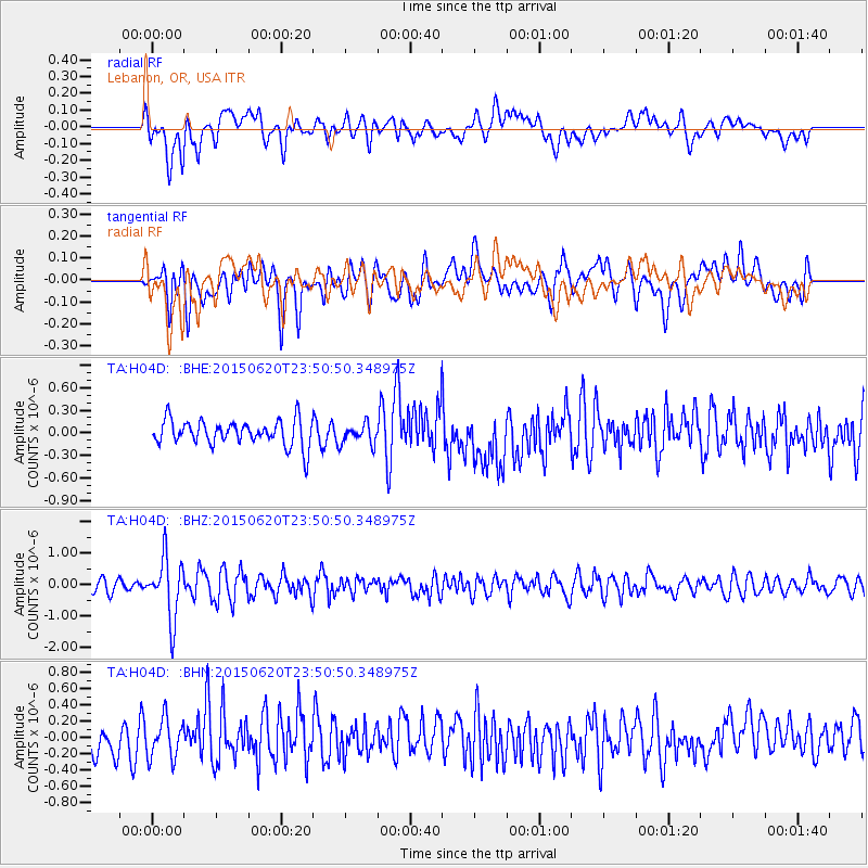
H04D Lebanon, OR, USA - Earthquake Result Viewer
*The percent match for this event was below the threshold and hence no stack was calculated.
| Earthquake location: |
South Of Fiji Islands |
| Earthquake latitude/longitude: |
-23.6/-177.1 |
| Earthquake time(UTC): |
2015/06/20 (171) 23:39:09 GMT |
| Earthquake Depth: |
158 km |
| Earthquake Magnitude: |
5.9 MO |
| Earthquake Catalog/Contributor: |
NEIC PDE/NEIC ALERT |
|
| Network: |
TA USArray Transportable Network (new EarthScope stations) |
| Station: |
H04D Lebanon, OR, USA |
| Lat/Lon: |
44.52 N/122.74 W |
| Elevation: |
284 m |
|
| Distance: |
84.0 deg |
| Az: |
35.772 deg |
| Baz: |
228.58 deg |
| Ray Param: |
$rayparam |
*The percent match for this event was below the threshold and hence was not used in the summary stack. |
|
| Radial Match: |
60.253487 % |
| Radial Bump: |
400 |
| Transverse Match: |
57.50456 % |
| Transverse Bump: |
400 |
| SOD ConfigId: |
7422571 |
| Insert Time: |
2019-04-19 10:10:52.511 +0000 |
| GWidth: |
2.5 |
| Max Bumps: |
400 |
| Tol: |
0.001 |
|
Signal To Noise
| Channel | StoN | STA | LTA |
| TA:H04D: :BHZ:20150620T23:50:50.348975Z | 4.603325 | 9.564085E-7 | 2.0776471E-7 |
| TA:H04D: :BHN:20150620T23:50:50.348975Z | 1.1859059 | 2.414409E-7 | 2.0359194E-7 |
| TA:H04D: :BHE:20150620T23:50:50.348975Z | 1.1154777 | 1.9213972E-7 | 1.7224883E-7 |
| Arrivals |
| Ps | |
| PpPs | |
| PsPs/PpSs | |


