You are here: Home > Network List > TA - USArray Transportable Network (new EarthScope stations) Stations List
> Station L04D Klamath Falls, OR, USA > Earthquake Result Viewer
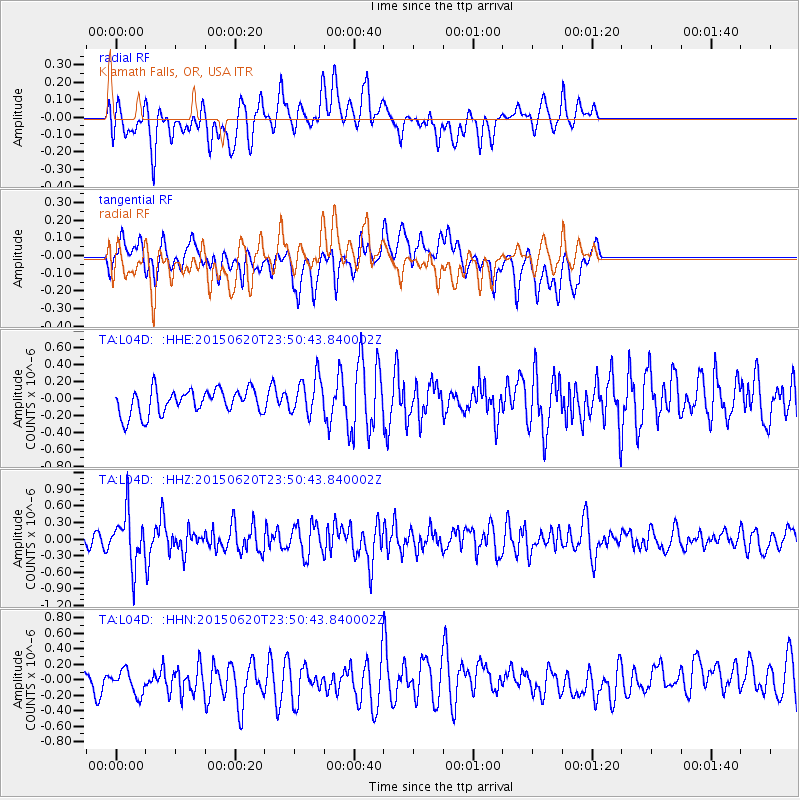
L04D Klamath Falls, OR, USA - Earthquake Result Viewer
*The percent match for this event was below the threshold and hence no stack was calculated.
| Earthquake location: |
South Of Fiji Islands |
| Earthquake latitude/longitude: |
-23.6/-177.1 |
| Earthquake time(UTC): |
2015/06/20 (171) 23:39:09 GMT |
| Earthquake Depth: |
158 km |
| Earthquake Magnitude: |
5.9 MO |
| Earthquake Catalog/Contributor: |
NEIC PDE/NEIC ALERT |
|
| Network: |
TA USArray Transportable Network (new EarthScope stations) |
| Station: |
L04D Klamath Falls, OR, USA |
| Lat/Lon: |
42.22 N/122.30 W |
| Elevation: |
1437 m |
|
| Distance: |
82.7 deg |
| Az: |
37.728 deg |
| Baz: |
229.103 deg |
| Ray Param: |
$rayparam |
*The percent match for this event was below the threshold and hence was not used in the summary stack. |
|
| Radial Match: |
54.581818 % |
| Radial Bump: |
400 |
| Transverse Match: |
47.260357 % |
| Transverse Bump: |
400 |
| SOD ConfigId: |
7422571 |
| Insert Time: |
2019-04-19 10:11:06.165 +0000 |
| GWidth: |
2.5 |
| Max Bumps: |
400 |
| Tol: |
0.001 |
|
Signal To Noise
| Channel | StoN | STA | LTA |
| TA:L04D: :HHZ:20150620T23:50:43.840002Z | 4.054286 | 4.6948801E-7 | 1.1580042E-7 |
| TA:L04D: :HHN:20150620T23:50:43.840002Z | 1.5770001 | 1.7743395E-7 | 1.1251359E-7 |
| TA:L04D: :HHE:20150620T23:50:43.840002Z | 1.6343528 | 2.4156125E-7 | 1.478024E-7 |
| Arrivals |
| Ps | |
| PpPs | |
| PsPs/PpSs | |


