You are here: Home > Network List > TA - USArray Transportable Network (new EarthScope stations) Stations List
> Station N25K Chitina, Valdez-Cordova, AK, USA > Earthquake Result Viewer
N25K Chitina, Valdez-Cordova, AK, USA - Earthquake Result Viewer
| Earthquake location: |
South Of Fiji Islands |
| Earthquake latitude/longitude: |
-23.6/-177.1 |
| Earthquake time(UTC): |
2015/06/20 (171) 23:39:09 GMT |
| Earthquake Depth: |
158 km |
| Earthquake Magnitude: |
5.9 MO |
| Earthquake Catalog/Contributor: |
NEIC PDE/NEIC ALERT |
|
| Network: |
TA USArray Transportable Network (new EarthScope stations) |
| Station: |
N25K Chitina, Valdez-Cordova, AK, USA |
| Lat/Lon: |
61.61 N/144.60 W |
| Elevation: |
1087 m |
|
| Distance: |
88.8 deg |
| Az: |
14.886 deg |
| Baz: |
209.549 deg |
| Ray Param: |
0.041964974 |
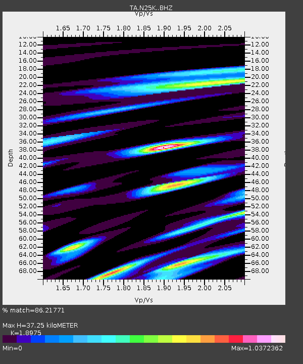
| Estimated Moho Depth: |
37.25 km |
| Estimated Crust Vp/Vs: |
1.90 |
| Assumed Crust Vp: |
6.566 km/s |
| Estimated Crust Vs: |
3.46 km/s |
| Estimated Crust Poisson's Ratio: |
0.31 |
|
| Radial Match: |
86.21771 % |
| Radial Bump: |
400 |
| Transverse Match: |
86.32046 % |
| Transverse Bump: |
400 |
| SOD ConfigId: |
7422571 |
| Insert Time: |
2019-04-19 10:11:13.746 +0000 |
| GWidth: |
2.5 |
| Max Bumps: |
400 |
| Tol: |
0.001 |
|
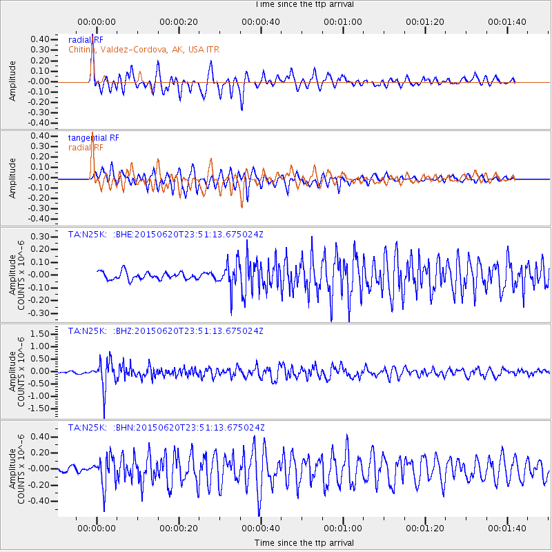
Signal To Noise
| Channel | StoN | STA | LTA |
| TA:N25K: :BHZ:20150620T23:51:13.675024Z | 17.514301 | 5.5252815E-7 | 3.154726E-8 |
| TA:N25K: :BHN:20150620T23:51:13.675024Z | 5.4064555 | 1.80171E-7 | 3.3325158E-8 |
| TA:N25K: :BHE:20150620T23:51:13.675024Z | 4.147046 | 1.1322147E-7 | 2.7301713E-8 |
| Arrivals |
| Ps | 5.2 SECOND |
| PpPs | 16 SECOND |
| PsPs/PpSs | 21 SECOND |


