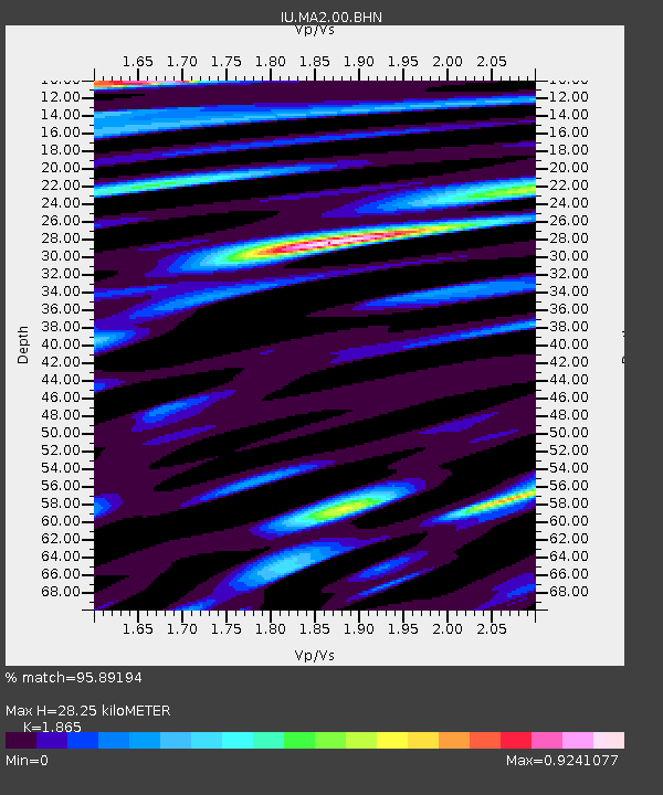
MA2 Magadan, Russia - Earthquake Result Viewer

Earthquake location: Western Xizang-India Border Reg.
Earthquake latitude/longitude: 30.5/79.4
Earthquake time(UTC): 1999/03/28 (087) 19:05:11 GMT
Earthquake Depth: 15 km
Earthquake Magnitude: 6.4 MB, 6.6 MS, 6.6 MW, 6.5 ME
Earthquake Catalog/Contributor: WHDF/NEIC
Network: IU Global Seismograph Network (GSN - IRIS/USGS)
Station: MA2 Magadan, Russia
Lat/Lon: 59.58 N/150.77 E
Elevation: 339 m
Distance: 54.9 deg
Az: 36.125 deg
Baz: 271.384 deg
Ray Param: 0.06514776
Estimated Moho Depth: 28.25 km
Estimated Crust Vp/Vs: 1.87
Assumed Crust Vp: 6.134 km/s
Estimated Crust Vs: 3.289 km/s
Estimated Crust Poisson's Ratio: 0.30
Radial Match: 95.89194 %
Radial Bump: 400
Transverse Match: 91.3889 %
Transverse Bump: 400
SOD ConfigId: 4480
Insert Time: 2010-03-03 14:59:51.130 +0000
GWidth: 2.5
Max Bumps: 400
Tol: 0.001

Signal To Noise

ChannelStoNSTALTA
IU:MA2:00:BHN:19990328T19:14:09.798005Z36.976232.6843807E-67.2597466E-8
IU:MA2:00:BHE:19990328T19:14:09.798005Z0.6463084.5839833E-87.092567E-8
IU:MA2:00:BHZ:19990328T19:14:09.798005Z14.6673041.3285311E-69.057773E-8
Arrivals
Ps4.2 SECOND
PpPs13 SECOND
PsPs/PpSs17 SECOND