You are here: Home > Network List > YT07 - POLENET Stations List
> Station SURP SURP > Earthquake Result Viewer
SURP SURP - Earthquake Result Viewer
| Earthquake location: |
South Of Fiji Islands |
| Earthquake latitude/longitude: |
-23.6/-177.1 |
| Earthquake time(UTC): |
2015/06/20 (171) 23:39:09 GMT |
| Earthquake Depth: |
158 km |
| Earthquake Magnitude: |
5.9 MO |
| Earthquake Catalog/Contributor: |
NEIC PDE/NEIC ALERT |
|
| Network: |
YT POLENET |
| Station: |
SURP SURP |
| Lat/Lon: |
84.72 S/171.20 W |
| Elevation: |
407 m |
|
| Distance: |
61.3 deg |
| Az: |
179.378 deg |
| Baz: |
353.828 deg |
| Ray Param: |
0.06049952 |
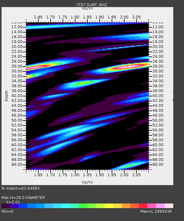
| Estimated Moho Depth: |
28.0 km |
| Estimated Crust Vp/Vs: |
2.01 |
| Assumed Crust Vp: |
6.245 km/s |
| Estimated Crust Vs: |
3.107 km/s |
| Estimated Crust Poisson's Ratio: |
0.34 |
|
| Radial Match: |
83.54593 % |
| Radial Bump: |
400 |
| Transverse Match: |
74.588295 % |
| Transverse Bump: |
400 |
| SOD ConfigId: |
7422571 |
| Insert Time: |
2019-04-19 10:13:50.516 +0000 |
| GWidth: |
2.5 |
| Max Bumps: |
400 |
| Tol: |
0.001 |
|

Signal To Noise
| Channel | StoN | STA | LTA |
| YT:SURP: :BHZ:20150620T23:48:36.725012Z | 2.6504424 | 2.8991272E-7 | 1.09382775E-7 |
| YT:SURP: :BHN:20150620T23:48:36.725012Z | 1.3993868 | 1.5492694E-7 | 1.10710594E-7 |
| YT:SURP: :BHE:20150620T23:48:36.725012Z | 1.005966 | 8.86674E-8 | 8.814156E-8 |
| Arrivals |
| Ps | 4.7 SECOND |
| PpPs | 13 SECOND |
| PsPs/PpSs | 18 SECOND |


