You are here: Home > Network List > 1U - Mt. Paektu Seismic Network Stations List
> Station JGPD Jang Gun Peak > Earthquake Result Viewer
JGPD Jang Gun Peak - Earthquake Result Viewer
| Earthquake location: |
Fiji Islands Region |
| Earthquake latitude/longitude: |
-20.5/-178.4 |
| Earthquake time(UTC): |
2015/06/21 (172) 21:28:16 GMT |
| Earthquake Depth: |
563 km |
| Earthquake Magnitude: |
6.5 MO |
| Earthquake Catalog/Contributor: |
NEIC PDE/NEIC ALERT |
|
| Network: |
1U Mt. Paektu Seismic Network |
| Station: |
JGPD Jang Gun Peak |
| Lat/Lon: |
41.99 N/128.08 E |
| Elevation: |
2648 m |
|
| Distance: |
79.4 deg |
| Az: |
322.403 deg |
| Baz: |
129.872 deg |
| Ray Param: |
0.04724724 |
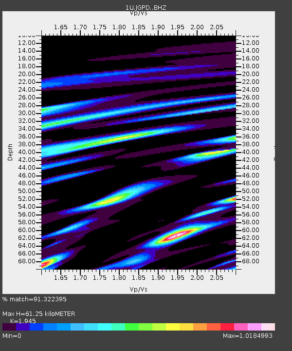
| Estimated Moho Depth: |
61.25 km |
| Estimated Crust Vp/Vs: |
1.95 |
| Assumed Crust Vp: |
6.472 km/s |
| Estimated Crust Vs: |
3.327 km/s |
| Estimated Crust Poisson's Ratio: |
0.32 |
|
| Radial Match: |
91.322395 % |
| Radial Bump: |
302 |
| Transverse Match: |
80.5023 % |
| Transverse Bump: |
400 |
| SOD ConfigId: |
7422571 |
| Insert Time: |
2019-04-19 10:14:25.711 +0000 |
| GWidth: |
2.5 |
| Max Bumps: |
400 |
| Tol: |
0.001 |
|

Signal To Noise
| Channel | StoN | STA | LTA |
| 1U:JGPD: :BHZ:20150621T21:38:52.699988Z | 17.723043 | 2.7108313E-6 | 1.5295518E-7 |
| 1U:JGPD: :BHN:20150621T21:38:52.699988Z | 5.8506002 | 1.1826783E-6 | 2.021465E-7 |
| 1U:JGPD: :BHE:20150621T21:38:52.699988Z | 9.842733 | 2.1288631E-6 | 2.1628779E-7 |
| Arrivals |
| Ps | 9.2 SECOND |
| PpPs | 27 SECOND |
| PsPs/PpSs | 36 SECOND |


