You are here: Home > Network List > AK - Alaska Regional Network Stations List
> Station BCP Bancas Point, AK, USA > Earthquake Result Viewer
BCP Bancas Point, AK, USA - Earthquake Result Viewer
| Earthquake location: |
Fiji Islands Region |
| Earthquake latitude/longitude: |
-20.5/-178.4 |
| Earthquake time(UTC): |
2015/06/21 (172) 21:28:16 GMT |
| Earthquake Depth: |
563 km |
| Earthquake Magnitude: |
6.5 MO |
| Earthquake Catalog/Contributor: |
NEIC PDE/NEIC ALERT |
|
| Network: |
AK Alaska Regional Network |
| Station: |
BCP Bancas Point, AK, USA |
| Lat/Lon: |
59.95 N/139.63 W |
| Elevation: |
422 m |
|
| Distance: |
86.1 deg |
| Az: |
18.389 deg |
| Baz: |
216.005 deg |
| Ray Param: |
0.04268127 |
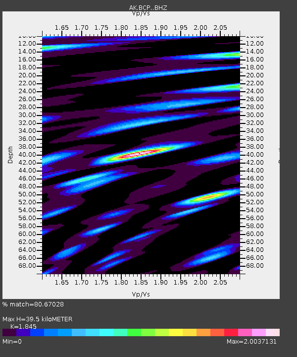
| Estimated Moho Depth: |
39.5 km |
| Estimated Crust Vp/Vs: |
1.85 |
| Assumed Crust Vp: |
6.183 km/s |
| Estimated Crust Vs: |
3.351 km/s |
| Estimated Crust Poisson's Ratio: |
0.29 |
|
| Radial Match: |
80.67028 % |
| Radial Bump: |
400 |
| Transverse Match: |
62.03435 % |
| Transverse Bump: |
400 |
| SOD ConfigId: |
7422571 |
| Insert Time: |
2019-04-19 10:14:38.808 +0000 |
| GWidth: |
2.5 |
| Max Bumps: |
400 |
| Tol: |
0.001 |
|

Signal To Noise
| Channel | StoN | STA | LTA |
| AK:BCP: :BHZ:20150621T21:39:26.108008Z | 11.358611 | 1.5237314E-6 | 1.341477E-7 |
| AK:BCP: :BHN:20150621T21:39:26.108008Z | 2.5560205 | 6.065316E-7 | 2.3729528E-7 |
| AK:BCP: :BHE:20150621T21:39:26.108008Z | 2.1377096 | 5.3377227E-7 | 2.4969356E-7 |
| Arrivals |
| Ps | 5.5 SECOND |
| PpPs | 18 SECOND |
| PsPs/PpSs | 23 SECOND |


