You are here: Home > Network List > TA - USArray Transportable Network (new EarthScope stations) Stations List
> Station MSTX Muleshoe, TX, USA > Earthquake Result Viewer
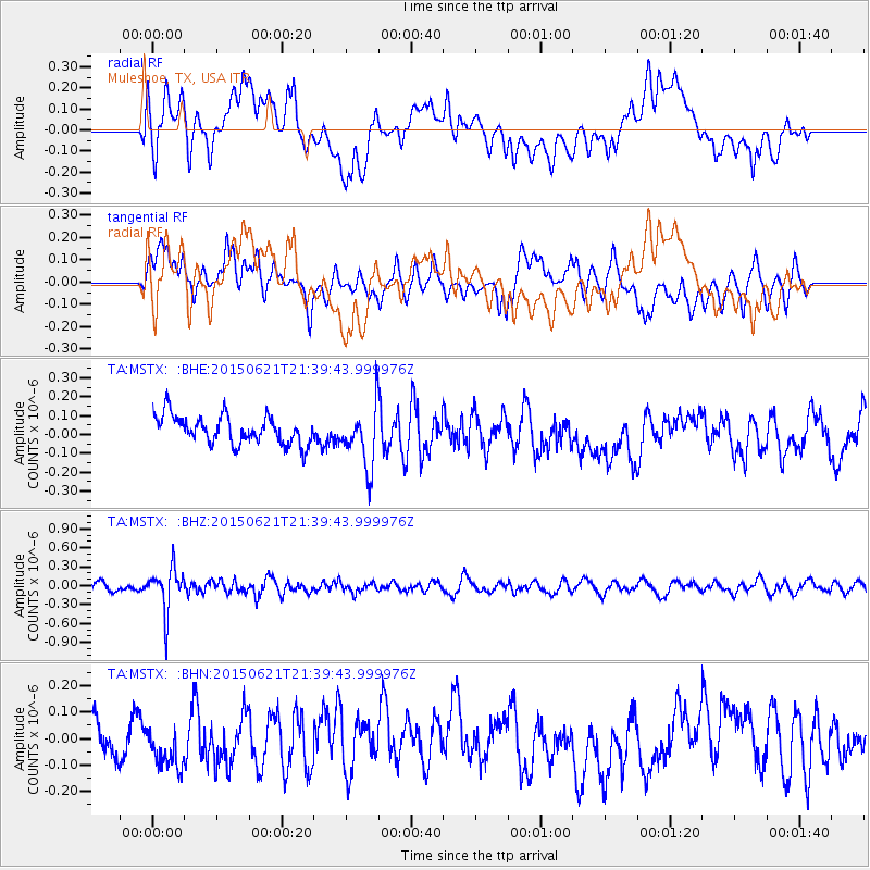
MSTX Muleshoe, TX, USA - Earthquake Result Viewer
*The percent match for this event was below the threshold and hence no stack was calculated.
| Earthquake location: |
Fiji Islands Region |
| Earthquake latitude/longitude: |
-20.5/-178.4 |
| Earthquake time(UTC): |
2015/06/21 (172) 21:28:16 GMT |
| Earthquake Depth: |
563 km |
| Earthquake Magnitude: |
6.5 MO |
| Earthquake Catalog/Contributor: |
NEIC PDE/NEIC ALERT |
|
| Network: |
TA USArray Transportable Network (new EarthScope stations) |
| Station: |
MSTX Muleshoe, TX, USA |
| Lat/Lon: |
33.97 N/102.77 W |
| Elevation: |
1167 m |
|
| Distance: |
89.9 deg |
| Az: |
53.599 deg |
| Baz: |
245.253 deg |
| Ray Param: |
$rayparam |
*The percent match for this event was below the threshold and hence was not used in the summary stack. |
|
| Radial Match: |
60.973194 % |
| Radial Bump: |
400 |
| Transverse Match: |
48.80461 % |
| Transverse Bump: |
400 |
| SOD ConfigId: |
7422571 |
| Insert Time: |
2019-04-19 10:20:46.502 +0000 |
| GWidth: |
2.5 |
| Max Bumps: |
400 |
| Tol: |
0.001 |
|
Signal To Noise
| Channel | StoN | STA | LTA |
| TA:MSTX: :BHZ:20150621T21:39:43.999976Z | 4.753693 | 3.4166976E-7 | 7.1874595E-8 |
| TA:MSTX: :BHN:20150621T21:39:43.999976Z | 0.9479607 | 8.194388E-8 | 8.6442284E-8 |
| TA:MSTX: :BHE:20150621T21:39:43.999976Z | 2.3272536 | 1.7111182E-7 | 7.3525214E-8 |
| Arrivals |
| Ps | |
| PpPs | |
| PsPs/PpSs | |


