You are here: Home > Network List > IU - Global Seismograph Network (GSN - IRIS/USGS) Stations List
> Station MA2 Magadan, Russia > Earthquake Result Viewer
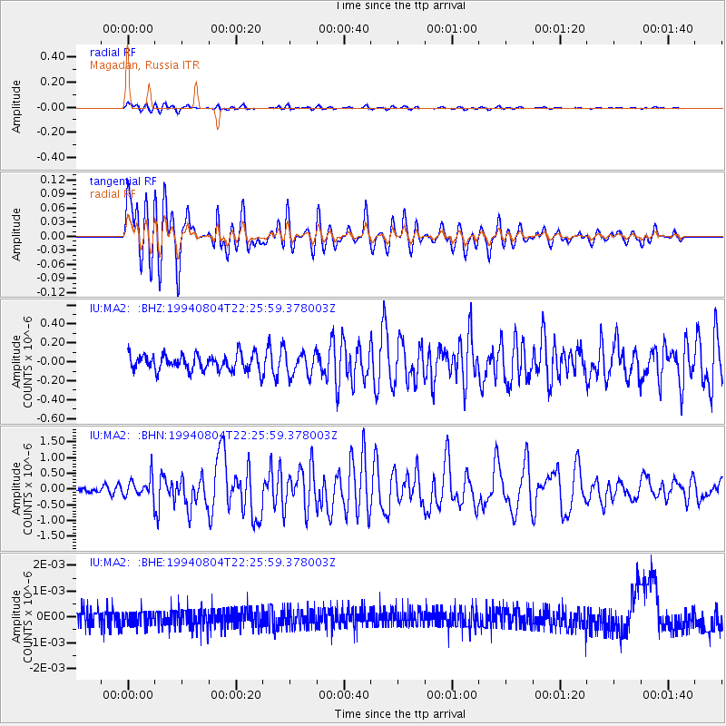
MA2 Magadan, Russia - Earthquake Result Viewer
*The percent match for this event was below the threshold and hence no stack was calculated.
| Earthquake location: |
Tanimbar Islands Reg., Indonesia |
| Earthquake latitude/longitude: |
-6.3/131.5 |
| Earthquake time(UTC): |
1994/08/04 (216) 22:15:37 GMT |
| Earthquake Depth: |
33 km |
| Earthquake Magnitude: |
6.1 MB, 5.6 MS, 6.1 UNKNOWN |
| Earthquake Catalog/Contributor: |
WHDF/NEIC |
|
| Network: |
IU Global Seismograph Network (GSN - IRIS/USGS) |
| Station: |
MA2 Magadan, Russia |
| Lat/Lon: |
59.58 N/150.77 E |
| Elevation: |
339 m |
|
| Distance: |
67.5 deg |
| Az: |
10.459 deg |
| Baz: |
200.767 deg |
| Ray Param: |
$rayparam |
*The percent match for this event was below the threshold and hence was not used in the summary stack. |
|
| Radial Match: |
71.978355 % |
| Radial Bump: |
400 |
| Transverse Match: |
71.91606 % |
| Transverse Bump: |
400 |
| SOD ConfigId: |
4480 |
| Insert Time: |
2010-03-03 15:03:01.423 +0000 |
| GWidth: |
2.5 |
| Max Bumps: |
400 |
| Tol: |
0.001 |
|
Signal To Noise
| Channel | StoN | STA | LTA |
| IU:MA2: :BHN:19940804T22:25:59.378003Z | 3.0894341 | 3.256194E-7 | 1.05397746E-7 |
| IU:MA2: :BHE:19940804T22:25:59.378003Z | 0.7812987 | 2.5729666E-10 | 3.293192E-10 |
| IU:MA2: :BHZ:19940804T22:25:59.378003Z | 1.4891853 | 1.2558633E-7 | 8.4332235E-8 |
| Arrivals |
| Ps | |
| PpPs | |
| PsPs/PpSs | |


