You are here: Home > Network List > UW - Pacific Northwest Regional Seismic Network Stations List
> Station PASS Maple Falls, WA, USA > Earthquake Result Viewer
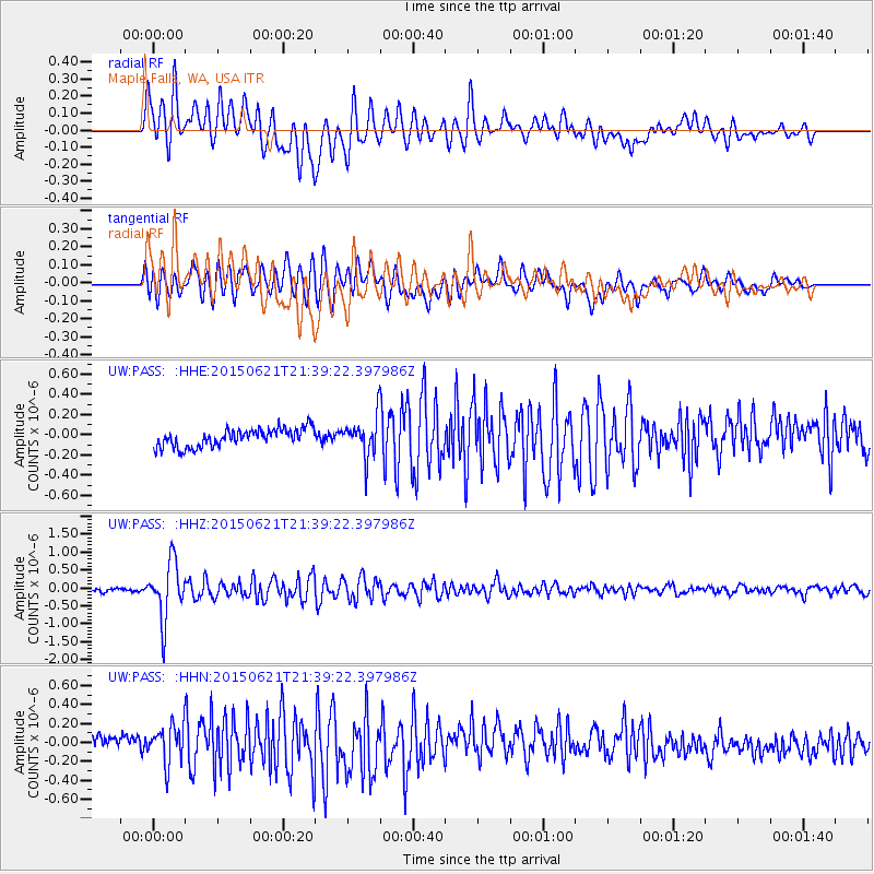
PASS Maple Falls, WA, USA - Earthquake Result Viewer
*The percent match for this event was below the threshold and hence no stack was calculated.
| Earthquake location: |
Fiji Islands Region |
| Earthquake latitude/longitude: |
-20.5/-178.4 |
| Earthquake time(UTC): |
2015/06/21 (172) 21:28:16 GMT |
| Earthquake Depth: |
563 km |
| Earthquake Magnitude: |
6.5 MO |
| Earthquake Catalog/Contributor: |
NEIC PDE/NEIC ALERT |
|
| Network: |
UW Pacific Northwest Regional Seismic Network |
| Station: |
PASS Maple Falls, WA, USA |
| Lat/Lon: |
49.00 N/122.09 W |
| Elevation: |
174 m |
|
| Distance: |
85.3 deg |
| Az: |
33.334 deg |
| Baz: |
231.483 deg |
| Ray Param: |
$rayparam |
*The percent match for this event was below the threshold and hence was not used in the summary stack. |
|
| Radial Match: |
72.7985 % |
| Radial Bump: |
400 |
| Transverse Match: |
67.93992 % |
| Transverse Bump: |
400 |
| SOD ConfigId: |
7422571 |
| Insert Time: |
2019-04-19 10:21:52.589 +0000 |
| GWidth: |
2.5 |
| Max Bumps: |
400 |
| Tol: |
0.001 |
|
Signal To Noise
| Channel | StoN | STA | LTA |
| UW:PASS: :HHZ:20150621T21:39:22.397986Z | 12.866128 | 7.958824E-7 | 6.1858735E-8 |
| UW:PASS: :HHN:20150621T21:39:22.397986Z | 2.2780793 | 2.098377E-7 | 9.211167E-8 |
| UW:PASS: :HHE:20150621T21:39:22.397986Z | 2.820262 | 2.4328796E-7 | 8.626431E-8 |
| Arrivals |
| Ps | |
| PpPs | |
| PsPs/PpSs | |


