You are here: Home > Network List > IU - Global Seismograph Network (GSN - IRIS/USGS) Stations List
> Station MA2 Magadan, Russia > Earthquake Result Viewer
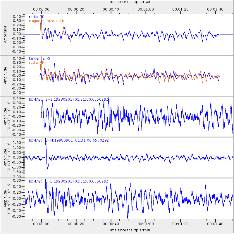
MA2 Magadan, Russia - Earthquake Result Viewer
*The percent match for this event was below the threshold and hence no stack was calculated.
| Earthquake location: |
Tonga Islands |
| Earthquake latitude/longitude: |
-17.6/-174.8 |
| Earthquake time(UTC): |
1998/09/01 (244) 01:19:37 GMT |
| Earthquake Depth: |
220 km |
| Earthquake Magnitude: |
5.6 UNKNOWN, 5.3 MB, 5.6 MW |
| Earthquake Catalog/Contributor: |
WHDF/NEIC |
|
| Network: |
IU Global Seismograph Network (GSN - IRIS/USGS) |
| Station: |
MA2 Magadan, Russia |
| Lat/Lon: |
59.58 N/150.77 E |
| Elevation: |
339 m |
|
| Distance: |
81.8 deg |
| Az: |
343.087 deg |
| Baz: |
146.952 deg |
| Ray Param: |
$rayparam |
*The percent match for this event was below the threshold and hence was not used in the summary stack. |
|
| Radial Match: |
60.730408 % |
| Radial Bump: |
400 |
| Transverse Match: |
59.69595 % |
| Transverse Bump: |
400 |
| SOD ConfigId: |
4480 |
| Insert Time: |
2010-03-03 15:03:34.881 +0000 |
| GWidth: |
2.5 |
| Max Bumps: |
400 |
| Tol: |
0.001 |
|
Signal To Noise
| Channel | StoN | STA | LTA |
| IU:MA2: :BHN:19980901T01:31:00.655029Z | 7.7301917 | 6.7187426E-7 | 8.6915605E-8 |
| IU:MA2: :BHE:19980901T01:31:00.655029Z | 1.8648003 | 2.5570512E-7 | 1.3712199E-7 |
| IU:MA2: :BHZ:19980901T01:31:00.655029Z | 1.2109216 | 1.5831843E-7 | 1.307421E-7 |
| Arrivals |
| Ps | |
| PpPs | |
| PsPs/PpSs | |


