You are here: Home > Network List > TA - USArray Transportable Network (new EarthScope stations) Stations List
> Station J01E Myrtle Point, OR, USA > Earthquake Result Viewer
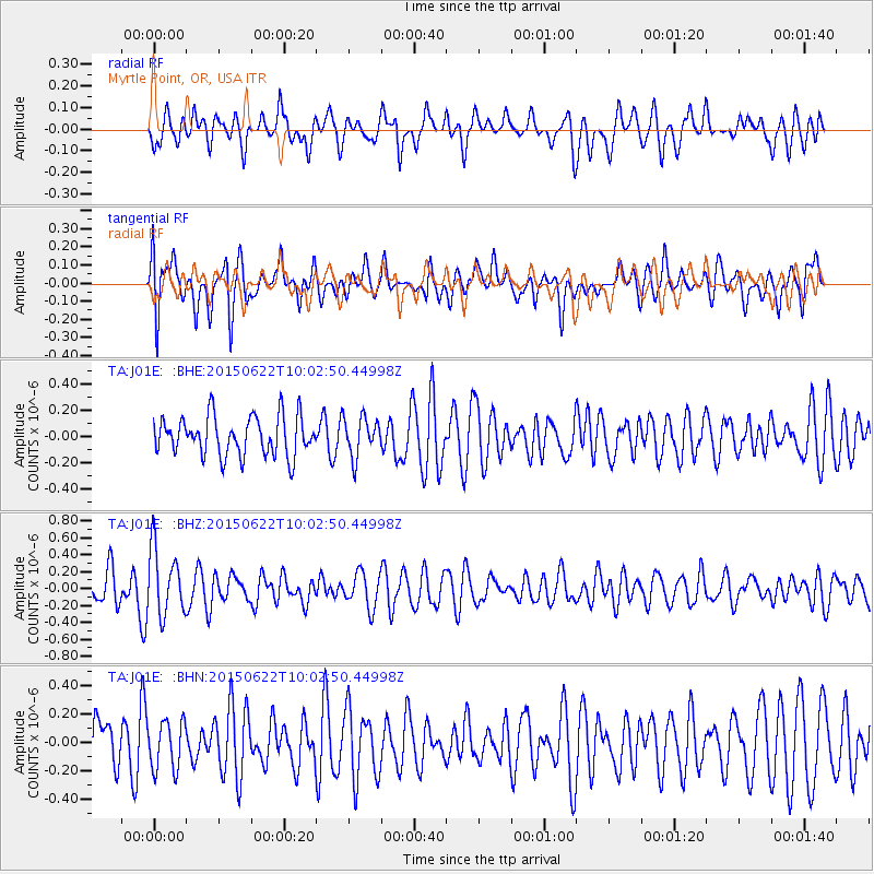
J01E Myrtle Point, OR, USA - Earthquake Result Viewer
*The percent match for this event was below the threshold and hence no stack was calculated.
| Earthquake location: |
Southeast Of Loyalty Islands |
| Earthquake latitude/longitude: |
-22.7/174.0 |
| Earthquake time(UTC): |
2015/06/22 (173) 09:50:40 GMT |
| Earthquake Depth: |
35 km |
| Earthquake Magnitude: |
3.9 mb |
| Earthquake Catalog/Contributor: |
ISC/ISC |
|
| Network: |
TA USArray Transportable Network (new EarthScope stations) |
| Station: |
J01E Myrtle Point, OR, USA |
| Lat/Lon: |
43.16 N/123.93 W |
| Elevation: |
128 m |
|
| Distance: |
86.8 deg |
| Az: |
40.366 deg |
| Baz: |
234.84 deg |
| Ray Param: |
$rayparam |
*The percent match for this event was below the threshold and hence was not used in the summary stack. |
|
| Radial Match: |
52.680157 % |
| Radial Bump: |
400 |
| Transverse Match: |
53.888817 % |
| Transverse Bump: |
400 |
| SOD ConfigId: |
7422571 |
| Insert Time: |
2019-04-19 10:27:24.329 +0000 |
| GWidth: |
2.5 |
| Max Bumps: |
400 |
| Tol: |
0.001 |
|
Signal To Noise
| Channel | StoN | STA | LTA |
| TA:J01E: :BHZ:20150622T10:02:50.44998Z | 1.8844278 | 3.9279647E-7 | 2.0844337E-7 |
| TA:J01E: :BHN:20150622T10:02:50.44998Z | 1.1323698 | 1.7118768E-7 | 1.511765E-7 |
| TA:J01E: :BHE:20150622T10:02:50.44998Z | 0.99829584 | 1.4807239E-7 | 1.4832516E-7 |
| Arrivals |
| Ps | |
| PpPs | |
| PsPs/PpSs | |


