You are here: Home > Network List > IU - Global Seismograph Network (GSN - IRIS/USGS) Stations List
> Station MA2 Magadan, Russia > Earthquake Result Viewer
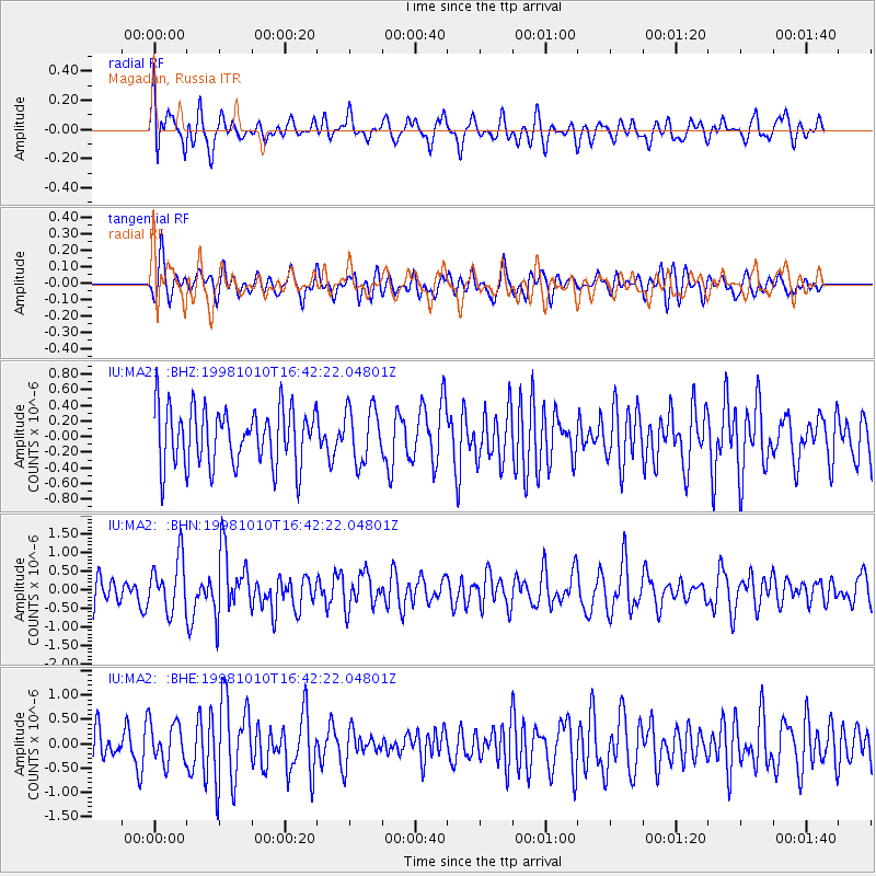
MA2 Magadan, Russia - Earthquake Result Viewer
*The percent match for this event was below the threshold and hence no stack was calculated.
| Earthquake location: |
Minahassa Peninsula, Sulawesi |
| Earthquake latitude/longitude: |
-0.4/119.8 |
| Earthquake time(UTC): |
1998/10/10 (283) 16:32:19 GMT |
| Earthquake Depth: |
33 km |
| Earthquake Magnitude: |
5.7 MB, 5.6 MS, 6.0 UNKNOWN, 6.0 MW |
| Earthquake Catalog/Contributor: |
WHDF/NEIC |
|
| Network: |
IU Global Seismograph Network (GSN - IRIS/USGS) |
| Station: |
MA2 Magadan, Russia |
| Lat/Lon: |
59.58 N/150.77 E |
| Elevation: |
339 m |
|
| Distance: |
64.5 deg |
| Az: |
16.847 deg |
| Baz: |
214.712 deg |
| Ray Param: |
$rayparam |
*The percent match for this event was below the threshold and hence was not used in the summary stack. |
|
| Radial Match: |
57.43856 % |
| Radial Bump: |
400 |
| Transverse Match: |
55.27411 % |
| Transverse Bump: |
398 |
| SOD ConfigId: |
4480 |
| Insert Time: |
2010-03-03 15:03:59.850 +0000 |
| GWidth: |
2.5 |
| Max Bumps: |
400 |
| Tol: |
0.001 |
|
Signal To Noise
| Channel | StoN | STA | LTA |
| IU:MA2: :BHN:19981010T16:42:22.04801Z | 2.0511227 | 7.1176436E-7 | 3.4701208E-7 |
| IU:MA2: :BHE:19981010T16:42:22.04801Z | 0.9200391 | 4.11581E-7 | 4.4735162E-7 |
| IU:MA2: :BHZ:19981010T16:42:22.04801Z | 0.94701654 | 3.463581E-7 | 3.6573607E-7 |
| Arrivals |
| Ps | |
| PpPs | |
| PsPs/PpSs | |


