You are here: Home > Network List > TA - USArray Transportable Network (new EarthScope stations) Stations List
> Station L04D Klamath Falls, OR, USA > Earthquake Result Viewer
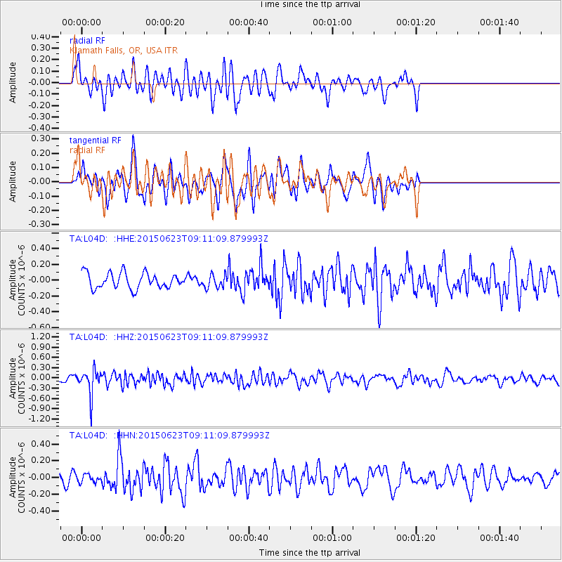
L04D Klamath Falls, OR, USA - Earthquake Result Viewer
*The percent match for this event was below the threshold and hence no stack was calculated.
| Earthquake location: |
Tonga Islands |
| Earthquake latitude/longitude: |
-19.7/-175.2 |
| Earthquake time(UTC): |
2015/06/23 (174) 08:59:54 GMT |
| Earthquake Depth: |
124 km |
| Earthquake Magnitude: |
5.6 MB |
| Earthquake Catalog/Contributor: |
NEIC PDE/NEIC ALERT |
|
| Network: |
TA USArray Transportable Network (new EarthScope stations) |
| Station: |
L04D Klamath Falls, OR, USA |
| Lat/Lon: |
42.22 N/122.30 W |
| Elevation: |
1437 m |
|
| Distance: |
78.6 deg |
| Az: |
37.195 deg |
| Baz: |
230.081 deg |
| Ray Param: |
$rayparam |
*The percent match for this event was below the threshold and hence was not used in the summary stack. |
|
| Radial Match: |
41.31741 % |
| Radial Bump: |
400 |
| Transverse Match: |
48.537384 % |
| Transverse Bump: |
400 |
| SOD ConfigId: |
7422571 |
| Insert Time: |
2019-04-19 10:35:25.975 +0000 |
| GWidth: |
2.5 |
| Max Bumps: |
400 |
| Tol: |
0.001 |
|
Signal To Noise
| Channel | StoN | STA | LTA |
| TA:L04D: :HHZ:20150623T09:11:09.879993Z | 4.3078475 | 3.7870024E-7 | 8.7909385E-8 |
| TA:L04D: :HHN:20150623T09:11:09.879993Z | 0.558286 | 4.6879883E-8 | 8.397109E-8 |
| TA:L04D: :HHE:20150623T09:11:09.879993Z | 1.1923357 | 1.0862194E-7 | 9.110013E-8 |
| Arrivals |
| Ps | |
| PpPs | |
| PsPs/PpSs | |


