You are here: Home > Network List > UW - Pacific Northwest Regional Seismic Network Stations List
> Station LEBA Lebam, WA, USA > Earthquake Result Viewer
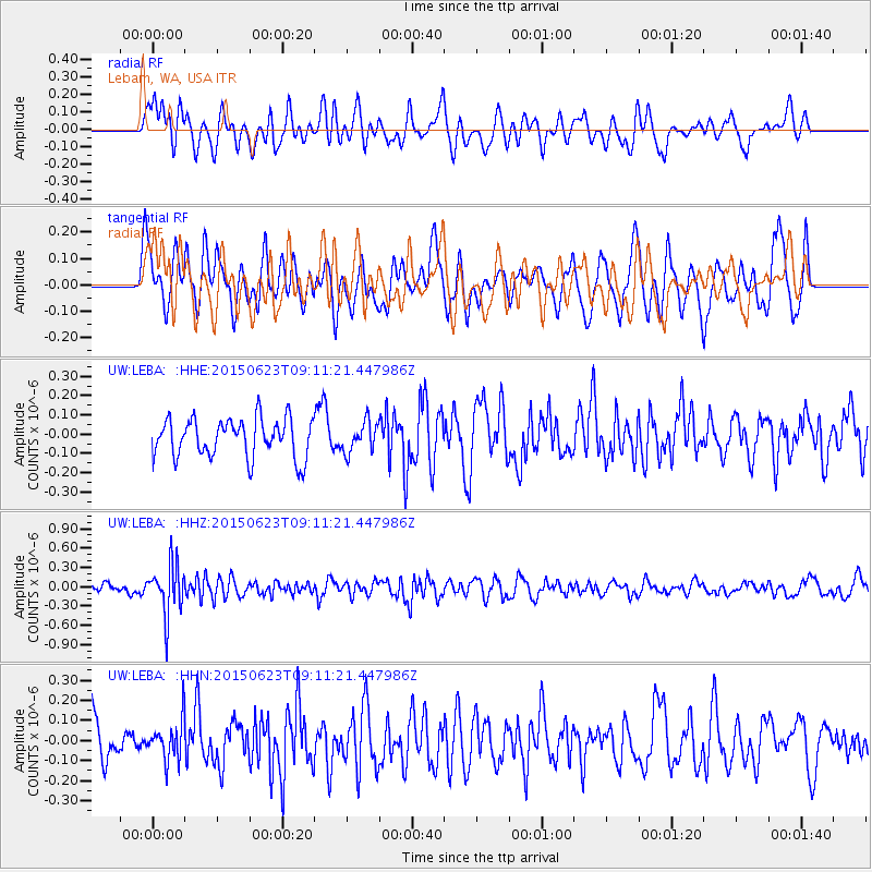
LEBA Lebam, WA, USA - Earthquake Result Viewer
*The percent match for this event was below the threshold and hence no stack was calculated.
| Earthquake location: |
Tonga Islands |
| Earthquake latitude/longitude: |
-19.7/-175.2 |
| Earthquake time(UTC): |
2015/06/23 (174) 08:59:54 GMT |
| Earthquake Depth: |
124 km |
| Earthquake Magnitude: |
5.6 MB |
| Earthquake Catalog/Contributor: |
NEIC PDE/NEIC ALERT |
|
| Network: |
UW Pacific Northwest Regional Seismic Network |
| Station: |
LEBA Lebam, WA, USA |
| Lat/Lon: |
46.55 N/123.56 W |
| Elevation: |
73 m |
|
| Distance: |
80.7 deg |
| Az: |
33.262 deg |
| Baz: |
228.495 deg |
| Ray Param: |
$rayparam |
*The percent match for this event was below the threshold and hence was not used in the summary stack. |
|
| Radial Match: |
48.073612 % |
| Radial Bump: |
400 |
| Transverse Match: |
54.984306 % |
| Transverse Bump: |
400 |
| SOD ConfigId: |
7422571 |
| Insert Time: |
2019-04-19 10:36:36.713 +0000 |
| GWidth: |
2.5 |
| Max Bumps: |
400 |
| Tol: |
0.001 |
|
Signal To Noise
| Channel | StoN | STA | LTA |
| UW:LEBA: :HHZ:20150623T09:11:21.447986Z | 5.5318255 | 3.9054072E-7 | 7.059889E-8 |
| UW:LEBA: :HHN:20150623T09:11:21.447986Z | 0.82825637 | 9.844012E-8 | 1.1885223E-7 |
| UW:LEBA: :HHE:20150623T09:11:21.447986Z | 0.7343318 | 7.8509586E-8 | 1.06912964E-7 |
| Arrivals |
| Ps | |
| PpPs | |
| PsPs/PpSs | |


