You are here: Home > Network List > AK - Alaska Regional Network Stations List
> Station RDOG Red Dog Mine, AK, USA > Earthquake Result Viewer
RDOG Red Dog Mine, AK, USA - Earthquake Result Viewer
| Earthquake location: |
Bonin Islands, Japan Region |
| Earthquake latitude/longitude: |
27.7/139.8 |
| Earthquake time(UTC): |
2015/06/23 (174) 12:18:29 GMT |
| Earthquake Depth: |
456 km |
| Earthquake Magnitude: |
6.3 MO |
| Earthquake Catalog/Contributor: |
NEIC PDE/NEIC ALERT |
|
| Network: |
AK Alaska Regional Network |
| Station: |
RDOG Red Dog Mine, AK, USA |
| Lat/Lon: |
68.05 N/162.90 W |
| Elevation: |
421 m |
|
| Distance: |
52.5 deg |
| Az: |
23.483 deg |
| Baz: |
250.088 deg |
| Ray Param: |
0.064795576 |
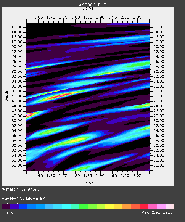
| Estimated Moho Depth: |
47.5 km |
| Estimated Crust Vp/Vs: |
1.60 |
| Assumed Crust Vp: |
5.906 km/s |
| Estimated Crust Vs: |
3.692 km/s |
| Estimated Crust Poisson's Ratio: |
0.18 |
|
| Radial Match: |
89.97595 % |
| Radial Bump: |
400 |
| Transverse Match: |
78.894455 % |
| Transverse Bump: |
400 |
| SOD ConfigId: |
7422571 |
| Insert Time: |
2019-04-19 10:39:24.020 +0000 |
| GWidth: |
2.5 |
| Max Bumps: |
400 |
| Tol: |
0.001 |
|

Signal To Noise
| Channel | StoN | STA | LTA |
| AK:RDOG: :BHZ:20150623T12:26:27.847998Z | 21.519947 | 1.1778698E-6 | 5.473386E-8 |
| AK:RDOG: :BHN:20150623T12:26:27.847998Z | 6.841398 | 3.1893978E-7 | 4.6619096E-8 |
| AK:RDOG: :BHE:20150623T12:26:27.847998Z | 15.096286 | 6.389859E-7 | 4.2327358E-8 |
| Arrivals |
| Ps | 5.1 SECOND |
| PpPs | 20 SECOND |
| PsPs/PpSs | 25 SECOND |


