You are here: Home > Network List > IU - Global Seismograph Network (GSN - IRIS/USGS) Stations List
> Station HRV Harvard, Massachusetts, USA > Earthquake Result Viewer
HRV Harvard, Massachusetts, USA - Earthquake Result Viewer

| Earthquake location: |
Off Coast Of Oregon |
| Earthquake latitude/longitude: |
43.5/-127.2 |
| Earthquake time(UTC): |
2002/07/09 (190) 18:40:35 GMT |
| Earthquake Depth: |
10 km |
| Earthquake Magnitude: |
5.5 MB, 5.5 MS, 6.0 MW, 5.8 MW |
| Earthquake Catalog/Contributor: |
WHDF/NEIC |
|
| Network: |
IU Global Seismograph Network (GSN - IRIS/USGS) |
| Station: |
HRV Harvard, Massachusetts, USA |
| Lat/Lon: |
42.51 N/71.56 W |
| Elevation: |
180 m |
|
| Distance: |
40.0 deg |
| Az: |
71.588 deg |
| Baz: |
291.03 deg |
| Ray Param: |
0.0746338 |
| Estimated Moho Depth: |
44.0 km |
| Estimated Crust Vp/Vs: |
1.61 |
| Assumed Crust Vp: |
6.419 km/s |
| Estimated Crust Vs: |
3.993 km/s |
| Estimated Crust Poisson's Ratio: |
0.18 |
|
| Radial Match: |
87.11507 % |
| Radial Bump: |
400 |
| Transverse Match: |
55.578014 % |
| Transverse Bump: |
400 |
| SOD ConfigId: |
87546 |
| Insert Time: |
2010-03-03 15:05:28.799 +0000 |
| GWidth: |
2.5 |
| Max Bumps: |
400 |
| Tol: |
0.001 |
|
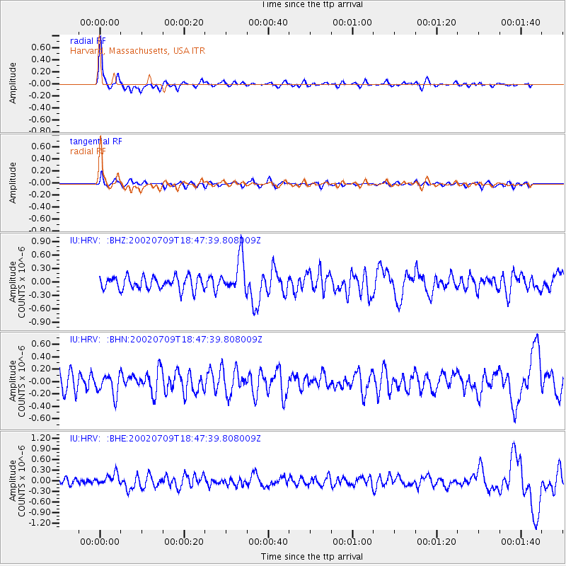
Signal To Noise
| Channel | StoN | STA | LTA |
| IU:HRV: :BHN:20020709T18:47:39.808009Z | 1.3067697 | 1.7114516E-7 | 1.309681E-7 |
| IU:HRV: :BHE:20020709T18:47:39.808009Z | 1.6551516 | 1.6206336E-7 | 9.791451E-8 |
| IU:HRV: :BHZ:20020709T18:47:39.808009Z | 2.9082007 | 4.1651853E-7 | 1.4322207E-7 |
| Arrivals |
| Ps | 4.5 SECOND |
| PpPs | 17 SECOND |
| PsPs/PpSs | 21 SECOND |


