You are here: Home > Network List > AV - Alaska Volcano Observatory Stations List
> Station AMKA Regional Station, Amchitka Island, Alaska > Earthquake Result Viewer
AMKA Regional Station, Amchitka Island, Alaska - Earthquake Result Viewer
| Earthquake location: |
Bonin Islands, Japan Region |
| Earthquake latitude/longitude: |
27.7/139.8 |
| Earthquake time(UTC): |
2015/06/23 (174) 12:18:29 GMT |
| Earthquake Depth: |
456 km |
| Earthquake Magnitude: |
6.3 MO |
| Earthquake Catalog/Contributor: |
NEIC PDE/NEIC ALERT |
|
| Network: |
AV Alaska Volcano Observatory |
| Station: |
AMKA Regional Station, Amchitka Island, Alaska |
| Lat/Lon: |
51.38 N/179.30 E |
| Elevation: |
116 m |
|
| Distance: |
37.9 deg |
| Az: |
40.444 deg |
| Baz: |
246.639 deg |
| Ray Param: |
0.07375459 |
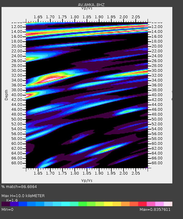
| Estimated Moho Depth: |
10.0 km |
| Estimated Crust Vp/Vs: |
1.60 |
| Assumed Crust Vp: |
6.183 km/s |
| Estimated Crust Vs: |
3.864 km/s |
| Estimated Crust Poisson's Ratio: |
0.18 |
|
| Radial Match: |
86.6864 % |
| Radial Bump: |
400 |
| Transverse Match: |
84.519936 % |
| Transverse Bump: |
400 |
| SOD ConfigId: |
7422571 |
| Insert Time: |
2019-04-19 10:40:04.865 +0000 |
| GWidth: |
2.5 |
| Max Bumps: |
400 |
| Tol: |
0.001 |
|

Signal To Noise
| Channel | StoN | STA | LTA |
| AV:AMKA: :BHZ:20150623T12:24:35.560004Z | 140.31136 | 6.9038974E-6 | 4.9204125E-8 |
| AV:AMKA: :BHN:20150623T12:24:35.560004Z | 18.773214 | 7.901396E-7 | 4.208867E-8 |
| AV:AMKA: :BHE:20150623T12:24:35.560004Z | 41.035023 | 1.4869008E-6 | 3.623492E-8 |
| Arrivals |
| Ps | 1.0 SECOND |
| PpPs | 3.9 SECOND |
| PsPs/PpSs | 5.0 SECOND |


