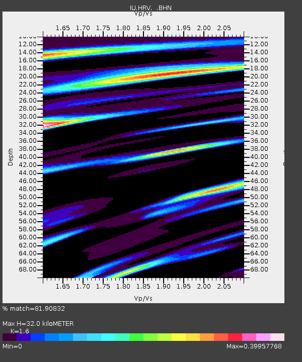
HRV Harvard, Massachusetts, USA - Earthquake Result Viewer
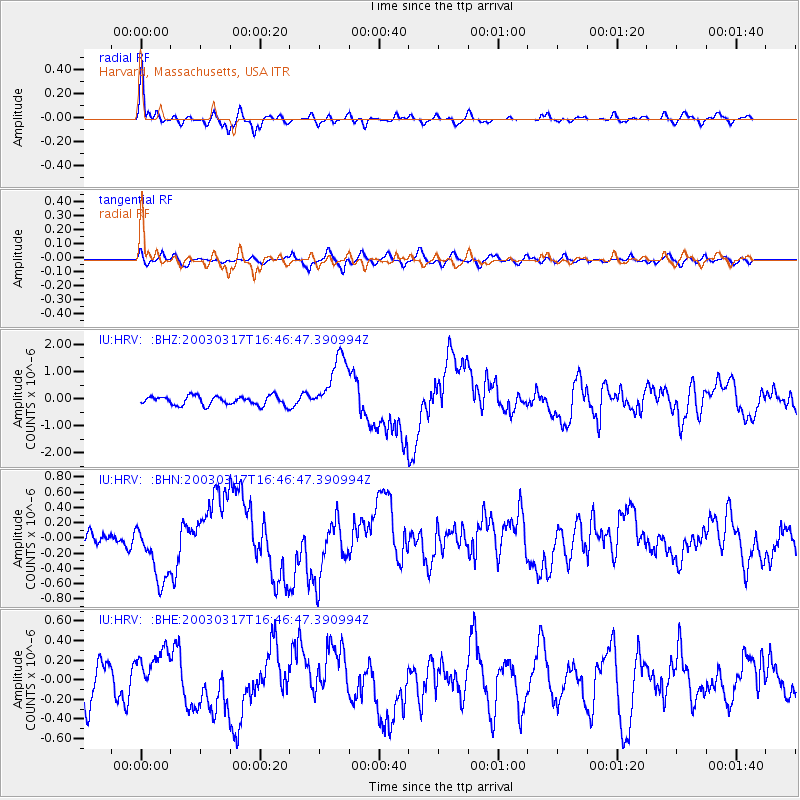
Earthquake location: Rat Islands, Aleutian Islands
Earthquake latitude/longitude: 51.3/178.0
Earthquake time(UTC): 2003/03/17 (076) 16:36:17 GMT
Earthquake Depth: 33 km
Earthquake Magnitude: 5.9 MB, 6.7 MS, 7.0 MW, 7.0 MW
Earthquake Catalog/Contributor: WHDF/NEIC
Network: IU Global Seismograph Network (GSN - IRIS/USGS)
Station: HRV Harvard, Massachusetts, USA
Lat/Lon: 42.51 N/71.56 W
Elevation: 180 m
Distance: 68.8 deg
Az: 47.989 deg
Baz: 320.862 deg
Ray Param: 0.05600711
Estimated Moho Depth: 32.0 km
Estimated Crust Vp/Vs: 1.60
Assumed Crust Vp: 6.419 km/s
Estimated Crust Vs: 4.012 km/s
Estimated Crust Poisson's Ratio: 0.18
Radial Match: 81.90832 %
Radial Bump: 400
Transverse Match: 44.9986 %
Transverse Bump: 400
SOD ConfigId: 4714
Insert Time: 2010-03-03 15:05:44.709 +0000
GWidth: 2.5
Max Bumps: 400
Tol: 0.001

Signal To Noise

ChannelStoNSTALTA
IU:HRV: :BHN:20030317T16:46:47.390994Z3.75581464.0303664E-71.0731004E-7
IU:HRV: :BHE:20030317T16:46:47.390994Z0.94151632.4113177E-72.5611E-7
IU:HRV: :BHZ:20030317T16:46:47.390994Z6.6847041.1038672E-61.651333E-7
Arrivals
Ps3.1 SECOND
PpPs12 SECOND
PsPs/PpSs16 SECOND