You are here: Home > Network List > IU - Global Seismograph Network (GSN - IRIS/USGS) Stations List
> Station HRV Harvard, Massachusetts, USA > Earthquake Result Viewer
HRV Harvard, Massachusetts, USA - Earthquake Result Viewer
| Earthquake location: |
Near West Coast Of Colombia |
| Earthquake latitude/longitude: |
4.7/-77.5 |
| Earthquake time(UTC): |
2004/11/15 (320) 09:06:56 GMT |
| Earthquake Depth: |
15 km |
| Earthquake Magnitude: |
6.6 MB, 7.1 MS, 7.2 MW, 7.1 MW |
| Earthquake Catalog/Contributor: |
WHDF/NEIC |
|
| Network: |
IU Global Seismograph Network (GSN - IRIS/USGS) |
| Station: |
HRV Harvard, Massachusetts, USA |
| Lat/Lon: |
42.51 N/71.56 W |
| Elevation: |
180 m |
|
| Distance: |
38.0 deg |
| Az: |
7.149 deg |
| Baz: |
189.656 deg |
| Ray Param: |
0.07578971 |
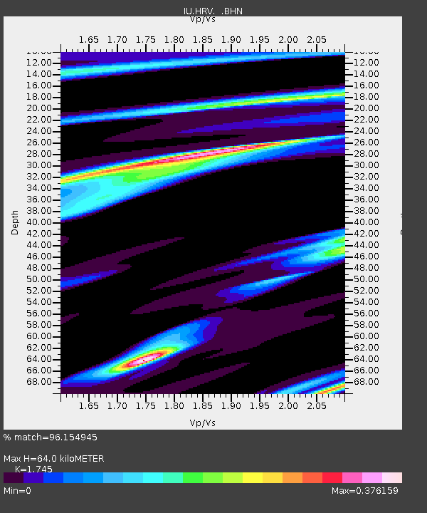
| Estimated Moho Depth: |
64.0 km |
| Estimated Crust Vp/Vs: |
1.75 |
| Assumed Crust Vp: |
6.419 km/s |
| Estimated Crust Vs: |
3.679 km/s |
| Estimated Crust Poisson's Ratio: |
0.26 |
|
| Radial Match: |
96.154945 % |
| Radial Bump: |
221 |
| Transverse Match: |
88.06263 % |
| Transverse Bump: |
400 |
| SOD ConfigId: |
2459 |
| Insert Time: |
2010-03-03 15:06:11.464 +0000 |
| GWidth: |
2.5 |
| Max Bumps: |
400 |
| Tol: |
0.001 |
|
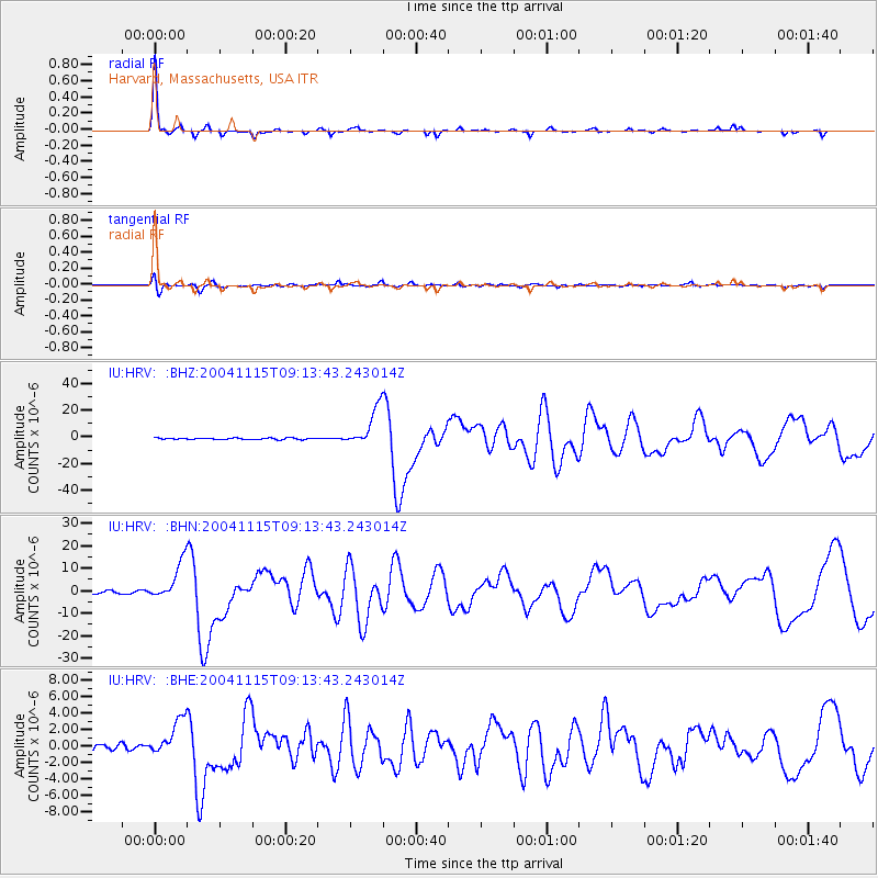
Signal To Noise
| Channel | StoN | STA | LTA |
| IU:HRV: :BHN:20041115T09:13:43.243014Z | 18.42807 | 8.721988E-6 | 4.7329908E-7 |
| IU:HRV: :BHE:20041115T09:13:43.243014Z | 5.6838846 | 2.2564411E-6 | 3.9698924E-7 |
| IU:HRV: :BHZ:20041115T09:13:43.243014Z | 26.476332 | 1.4455205E-5 | 5.4596705E-7 |
| Arrivals |
| Ps | 8.0 SECOND |
| PpPs | 25 SECOND |
| PsPs/PpSs | 33 SECOND |


