You are here: Home > Network List > IU - Global Seismograph Network (GSN - IRIS/USGS) Stations List
> Station HRV Harvard, Massachusetts, USA > Earthquake Result Viewer
HRV Harvard, Massachusetts, USA - Earthquake Result Viewer
| Earthquake location: |
South Pacific Ocean |
| Earthquake latitude/longitude: |
-20.3/-126.9 |
| Earthquake time(UTC): |
2004/07/11 (193) 23:46:12 GMT |
| Earthquake Depth: |
12 km |
| Earthquake Magnitude: |
6.1 MB, 5.9 MS, 6.1 MW, 6.1 MW |
| Earthquake Catalog/Contributor: |
WHDF/NEIC |
|
| Network: |
IU Global Seismograph Network (GSN - IRIS/USGS) |
| Station: |
HRV Harvard, Massachusetts, USA |
| Lat/Lon: |
42.51 N/71.56 W |
| Elevation: |
180 m |
|
| Distance: |
80.6 deg |
| Az: |
38.075 deg |
| Baz: |
231.541 deg |
| Ray Param: |
0.04814592 |
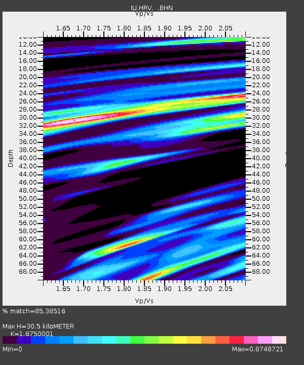
| Estimated Moho Depth: |
30.5 km |
| Estimated Crust Vp/Vs: |
1.68 |
| Assumed Crust Vp: |
6.419 km/s |
| Estimated Crust Vs: |
3.832 km/s |
| Estimated Crust Poisson's Ratio: |
0.22 |
|
| Radial Match: |
85.38516 % |
| Radial Bump: |
400 |
| Transverse Match: |
59.8921 % |
| Transverse Bump: |
400 |
| SOD ConfigId: |
2459 |
| Insert Time: |
2010-03-03 15:06:20.973 +0000 |
| GWidth: |
2.5 |
| Max Bumps: |
400 |
| Tol: |
0.001 |
|

Signal To Noise
| Channel | StoN | STA | LTA |
| IU:HRV: :BHN:20040711T23:57:53.601016Z | 1.8263731 | 5.091781E-7 | 2.7879193E-7 |
| IU:HRV: :BHE:20040711T23:57:53.601016Z | 4.5227566 | 5.9107595E-7 | 1.3068932E-7 |
| IU:HRV: :BHZ:20040711T23:57:53.601016Z | 10.182669 | 1.5468281E-6 | 1.5190794E-7 |
| Arrivals |
| Ps | 3.3 SECOND |
| PpPs | 12 SECOND |
| PsPs/PpSs | 16 SECOND |


