You are here: Home > Network List > IU - Global Seismograph Network (GSN - IRIS/USGS) Stations List
> Station HRV Harvard, Massachusetts, USA > Earthquake Result Viewer
HRV Harvard, Massachusetts, USA - Earthquake Result Viewer
| Earthquake location: |
Salta Province, Argentina |
| Earthquake latitude/longitude: |
-25.0/-63.5 |
| Earthquake time(UTC): |
2005/03/21 (080) 12:23:54 GMT |
| Earthquake Depth: |
579 km |
| Earthquake Magnitude: |
6.1 MB, 6.9 MW, 6.9 MW |
| Earthquake Catalog/Contributor: |
WHDF/NEIC |
|
| Network: |
IU Global Seismograph Network (GSN - IRIS/USGS) |
| Station: |
HRV Harvard, Massachusetts, USA |
| Lat/Lon: |
42.51 N/71.56 W |
| Elevation: |
180 m |
|
| Distance: |
67.6 deg |
| Az: |
353.537 deg |
| Baz: |
172.06 deg |
| Ray Param: |
0.054803383 |
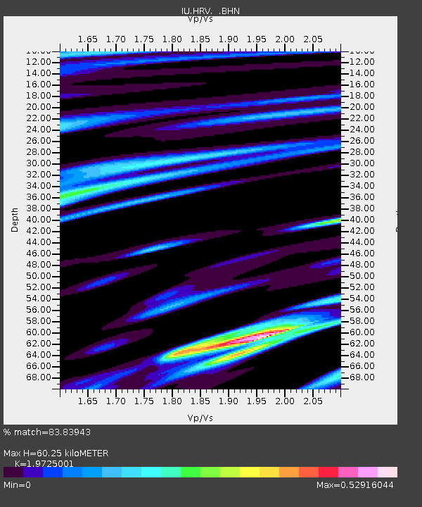
| Estimated Moho Depth: |
60.25 km |
| Estimated Crust Vp/Vs: |
1.97 |
| Assumed Crust Vp: |
6.419 km/s |
| Estimated Crust Vs: |
3.254 km/s |
| Estimated Crust Poisson's Ratio: |
0.33 |
|
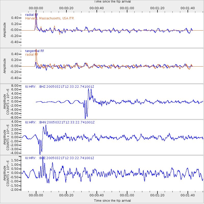
| Radial Match: |
83.83943 % |
| Radial Bump: |
400 |
| Transverse Match: |
66.3391 % |
| Transverse Bump: |
400 |
| SOD ConfigId: |
2459 |
| Insert Time: |
2010-03-03 15:06:37.449 +0000 |
| GWidth: |
2.5 |
| Max Bumps: |
400 |
| Tol: |
0.001 |
|
Signal To Noise
| Channel | StoN | STA | LTA |
| IU:HRV: :BHN:20050321T12:33:22.741001Z | 6.8483787 | 1.8936277E-6 | 2.7650745E-7 |
| IU:HRV: :BHE:20050321T12:33:22.741001Z | 3.9053175 | 6.516841E-7 | 1.6687098E-7 |
| IU:HRV: :BHZ:20050321T12:33:22.741001Z | 10.820826 | 3.878067E-6 | 3.5838923E-7 |
| Arrivals |
| Ps | 9.4 SECOND |
| PpPs | 27 SECOND |
| PsPs/PpSs | 36 SECOND |


