You are here: Home > Network List > TA - USArray Transportable Network (new EarthScope stations) Stations List
> Station J04D Umpqua National Forest, Toketee, OR, USA > Earthquake Result Viewer
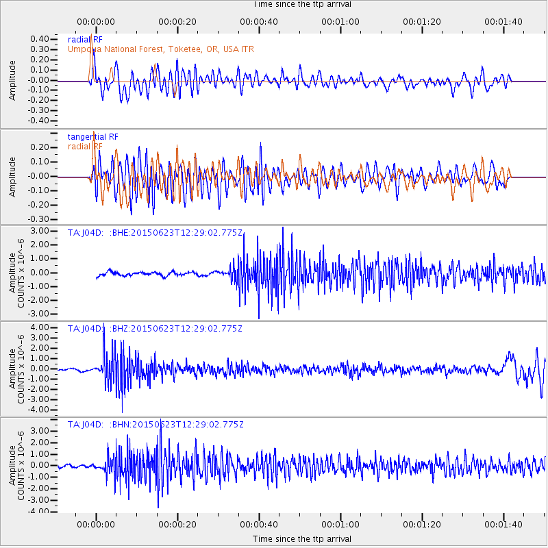
J04D Umpqua National Forest, Toketee, OR, USA - Earthquake Result Viewer
*The percent match for this event was below the threshold and hence no stack was calculated.
| Earthquake location: |
Bonin Islands, Japan Region |
| Earthquake latitude/longitude: |
27.7/139.8 |
| Earthquake time(UTC): |
2015/06/23 (174) 12:18:29 GMT |
| Earthquake Depth: |
456 km |
| Earthquake Magnitude: |
6.3 MO |
| Earthquake Catalog/Contributor: |
NEIC PDE/NEIC ALERT |
|
| Network: |
TA USArray Transportable Network (new EarthScope stations) |
| Station: |
J04D Umpqua National Forest, Toketee, OR, USA |
| Lat/Lon: |
43.24 N/122.11 W |
| Elevation: |
1948 m |
|
| Distance: |
77.1 deg |
| Az: |
47.933 deg |
| Baz: |
295.713 deg |
| Ray Param: |
$rayparam |
*The percent match for this event was below the threshold and hence was not used in the summary stack. |
|
| Radial Match: |
61.096207 % |
| Radial Bump: |
400 |
| Transverse Match: |
56.940853 % |
| Transverse Bump: |
400 |
| SOD ConfigId: |
7422571 |
| Insert Time: |
2019-04-19 10:45:47.499 +0000 |
| GWidth: |
2.5 |
| Max Bumps: |
400 |
| Tol: |
0.001 |
|
Signal To Noise
| Channel | StoN | STA | LTA |
| TA:J04D: :BHZ:20150623T12:29:02.775Z | 16.848421 | 1.3842517E-6 | 8.215914E-8 |
| TA:J04D: :BHN:20150623T12:29:02.775Z | 6.5501485 | 7.398229E-7 | 1.12947504E-7 |
| TA:J04D: :BHE:20150623T12:29:02.775Z | 5.422119 | 6.664436E-7 | 1.2291203E-7 |
| Arrivals |
| Ps | |
| PpPs | |
| PsPs/PpSs | |


