You are here: Home > Network List > IU - Global Seismograph Network (GSN - IRIS/USGS) Stations List
> Station HRV Harvard, Massachusetts, USA > Earthquake Result Viewer
HRV Harvard, Massachusetts, USA - Earthquake Result Viewer
| Earthquake location: |
Off Coast Of Northern California |
| Earthquake latitude/longitude: |
40.4/-125.3 |
| Earthquake time(UTC): |
2000/03/16 (076) 15:19:56 GMT |
| Earthquake Depth: |
7.8 km |
| Earthquake Magnitude: |
5.4 MB, 5.6 MS, 5.9 MW, 5.8 ML |
| Earthquake Catalog/Contributor: |
WHDF/NEIC |
|
| Network: |
IU Global Seismograph Network (GSN - IRIS/USGS) |
| Station: |
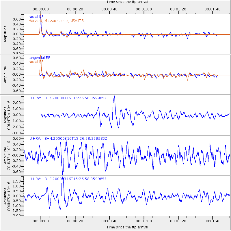
HRV Harvard, Massachusetts, USA |
| Lat/Lon: |
42.51 N/71.56 W |
| Elevation: |
180 m |
|
| Distance: |
39.8 deg |
| Az: |
68.75 deg |
| Baz: |
285.691 deg |
| Ray Param: |
0.074802116 |
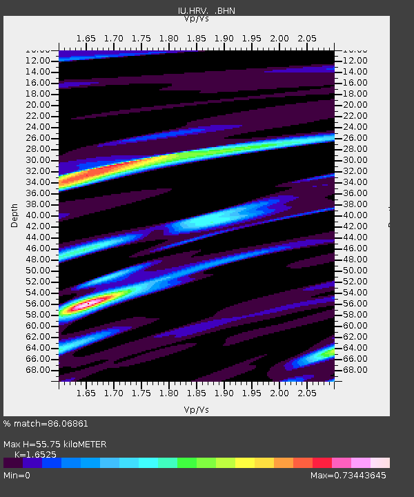
| Estimated Moho Depth: |
55.75 km |
| Estimated Crust Vp/Vs: |
1.65 |
| Assumed Crust Vp: |
6.419 km/s |
| Estimated Crust Vs: |
3.885 km/s |
| Estimated Crust Poisson's Ratio: |
0.21 |
|
| Radial Match: |
86.06861 % |
| Radial Bump: |
346 |
| Transverse Match: |
70.91858 % |
| Transverse Bump: |
400 |
| SOD ConfigId: |
3753 |
| Insert Time: |
2010-03-03 15:06:58.743 +0000 |
| GWidth: |
2.5 |
| Max Bumps: |
400 |
| Tol: |
0.001 |
|
Signal To Noise
| Channel | StoN | STA | LTA |
| IU:HRV: :BHN:20000316T15:26:58.359985Z | 1.0988773 | 1.5015426E-7 | 1.3664334E-7 |
| IU:HRV: :BHE:20000316T15:26:58.359985Z | 2.7863898 | 4.1133273E-7 | 1.4762212E-7 |
| IU:HRV: :BHZ:20000316T15:26:58.359985Z | 3.52291 | 6.3020093E-7 | 1.7888647E-7 |
| Arrivals |
| Ps | 6.1 SECOND |
| PpPs | 21 SECOND |
| PsPs/PpSs | 27 SECOND |


