You are here: Home > Network List > UW - Pacific Northwest Regional Seismic Network Stations List
> Station MRBL Marblemount, WA, USA > Earthquake Result Viewer
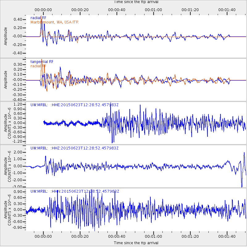
MRBL Marblemount, WA, USA - Earthquake Result Viewer
*The percent match for this event was below the threshold and hence no stack was calculated.
| Earthquake location: |
Bonin Islands, Japan Region |
| Earthquake latitude/longitude: |
27.7/139.8 |
| Earthquake time(UTC): |
2015/06/23 (174) 12:18:29 GMT |
| Earthquake Depth: |
456 km |
| Earthquake Magnitude: |
6.3 MO |
| Earthquake Catalog/Contributor: |
NEIC PDE/NEIC ALERT |
|
| Network: |
UW Pacific Northwest Regional Seismic Network |
| Station: |
MRBL Marblemount, WA, USA |
| Lat/Lon: |
48.52 N/121.48 W |
| Elevation: |
75 m |
|
| Distance: |
75.2 deg |
| Az: |
42.825 deg |
| Baz: |
294.935 deg |
| Ray Param: |
$rayparam |
*The percent match for this event was below the threshold and hence was not used in the summary stack. |
|
| Radial Match: |
70.16949 % |
| Radial Bump: |
400 |
| Transverse Match: |
70.518105 % |
| Transverse Bump: |
400 |
| SOD ConfigId: |
7422571 |
| Insert Time: |
2019-04-19 10:47:04.969 +0000 |
| GWidth: |
2.5 |
| Max Bumps: |
400 |
| Tol: |
0.001 |
|
Signal To Noise
| Channel | StoN | STA | LTA |
| UW:MRBL: :HHZ:20150623T12:28:52.457983Z | 11.395988 | 6.332715E-7 | 5.5569686E-8 |
| UW:MRBL: :HHN:20150623T12:28:52.457983Z | 3.541931 | 2.6175974E-7 | 7.3903124E-8 |
| UW:MRBL: :HHE:20150623T12:28:52.457983Z | 2.7355564 | 2.2905087E-7 | 8.3730995E-8 |
| Arrivals |
| Ps | |
| PpPs | |
| PsPs/PpSs | |


