You are here: Home > Network List > UW - Pacific Northwest Regional Seismic Network Stations List
> Station PASS Maple Falls, WA, USA > Earthquake Result Viewer
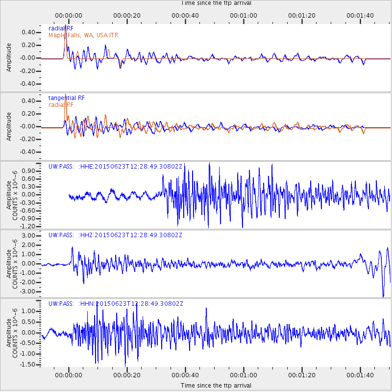
PASS Maple Falls, WA, USA - Earthquake Result Viewer
*The percent match for this event was below the threshold and hence no stack was calculated.
| Earthquake location: |
Bonin Islands, Japan Region |
| Earthquake latitude/longitude: |
27.7/139.8 |
| Earthquake time(UTC): |
2015/06/23 (174) 12:18:29 GMT |
| Earthquake Depth: |
456 km |
| Earthquake Magnitude: |
6.3 MO |
| Earthquake Catalog/Contributor: |
NEIC PDE/NEIC ALERT |
|
| Network: |
UW Pacific Northwest Regional Seismic Network |
| Station: |
PASS Maple Falls, WA, USA |
| Lat/Lon: |
49.00 N/122.09 W |
| Elevation: |
174 m |
|
| Distance: |
74.6 deg |
| Az: |
42.545 deg |
| Baz: |
294.411 deg |
| Ray Param: |
$rayparam |
*The percent match for this event was below the threshold and hence was not used in the summary stack. |
|
| Radial Match: |
71.70297 % |
| Radial Bump: |
400 |
| Transverse Match: |
52.188854 % |
| Transverse Bump: |
400 |
| SOD ConfigId: |
7422571 |
| Insert Time: |
2019-04-19 10:47:06.669 +0000 |
| GWidth: |
2.5 |
| Max Bumps: |
400 |
| Tol: |
0.001 |
|
Signal To Noise
| Channel | StoN | STA | LTA |
| UW:PASS: :HHZ:20150623T12:28:49.30802Z | 9.463763 | 7.054496E-7 | 7.4542186E-8 |
| UW:PASS: :HHN:20150623T12:28:49.30802Z | 2.912001 | 2.61606E-7 | 8.983721E-8 |
| UW:PASS: :HHE:20150623T12:28:49.30802Z | 3.0500116 | 3.1686253E-7 | 1.0388896E-7 |
| Arrivals |
| Ps | |
| PpPs | |
| PsPs/PpSs | |


