You are here: Home > Network List > IU - Global Seismograph Network (GSN - IRIS/USGS) Stations List
> Station HRV Harvard, Massachusetts, USA > Earthquake Result Viewer
HRV Harvard, Massachusetts, USA - Earthquake Result Viewer
| Earthquake location: |
Panama-Colombia Border Region |
| Earthquake latitude/longitude: |
7.0/-77.8 |
| Earthquake time(UTC): |
2000/11/08 (313) 06:59:58 GMT |
| Earthquake Depth: |
17 km |
| Earthquake Magnitude: |
6.0 MB, 6.4 MS, 6.5 MW, 6.2 ML |
| Earthquake Catalog/Contributor: |
WHDF/NEIC |
|
| Network: |
IU Global Seismograph Network (GSN - IRIS/USGS) |
| Station: |
HRV Harvard, Massachusetts, USA |
| Lat/Lon: |
42.51 N/71.56 W |
| Elevation: |
180 m |
|
| Distance: |
35.8 deg |
| Az: |
7.946 deg |
| Baz: |
190.694 deg |
| Ray Param: |
0.07703713 |
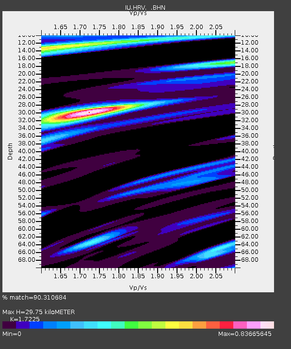
| Estimated Moho Depth: |
29.75 km |
| Estimated Crust Vp/Vs: |
1.72 |
| Assumed Crust Vp: |
6.419 km/s |
| Estimated Crust Vs: |
3.727 km/s |
| Estimated Crust Poisson's Ratio: |
0.25 |
|
| Radial Match: |
90.310684 % |
| Radial Bump: |
285 |
| Transverse Match: |
69.90869 % |
| Transverse Bump: |
400 |
| SOD ConfigId: |
3744 |
| Insert Time: |
2010-03-03 15:07:04.096 +0000 |
| GWidth: |
2.5 |
| Max Bumps: |
400 |
| Tol: |
0.001 |
|

Signal To Noise
| Channel | StoN | STA | LTA |
| IU:HRV: :BHN:20001108T07:06:26.013015Z | 3.7865148 | 1.1784296E-6 | 3.112175E-7 |
| IU:HRV: :BHE:20001108T07:06:26.013015Z | 1.2600976 | 4.7012693E-7 | 3.7308774E-7 |
| IU:HRV: :BHZ:20001108T07:06:26.013015Z | 5.402262 | 1.8353911E-6 | 3.3974493E-7 |
| Arrivals |
| Ps | 3.6 SECOND |
| PpPs | 12 SECOND |
| PsPs/PpSs | 15 SECOND |


