You are here: Home > Network List > WY - Yellowstone Wyoming Seismic Network Stations List
> Station YNR Norris Junction, YNP, WY, USA > Earthquake Result Viewer
YNR Norris Junction, YNP, WY, USA - Earthquake Result Viewer
| Earthquake location: |
Bonin Islands, Japan Region |
| Earthquake latitude/longitude: |
27.7/139.8 |
| Earthquake time(UTC): |
2015/06/23 (174) 12:18:29 GMT |
| Earthquake Depth: |
456 km |
| Earthquake Magnitude: |
6.3 MO |
| Earthquake Catalog/Contributor: |
NEIC PDE/NEIC ALERT |
|
| Network: |
WY Yellowstone Wyoming Seismic Network |
| Station: |
YNR Norris Junction, YNP, WY, USA |
| Lat/Lon: |
44.72 N/110.68 W |
| Elevation: |
2336 m |
|
| Distance: |
83.5 deg |
| Az: |
42.551 deg |
| Baz: |
302.727 deg |
| Ray Param: |
0.04484976 |
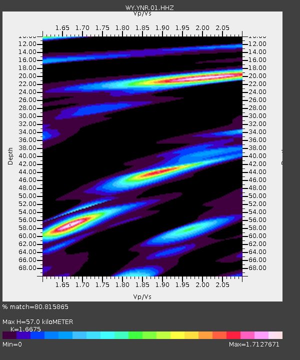
| Estimated Moho Depth: |
57.0 km |
| Estimated Crust Vp/Vs: |
1.67 |
| Assumed Crust Vp: |
6.35 km/s |
| Estimated Crust Vs: |
3.808 km/s |
| Estimated Crust Poisson's Ratio: |
0.22 |
|
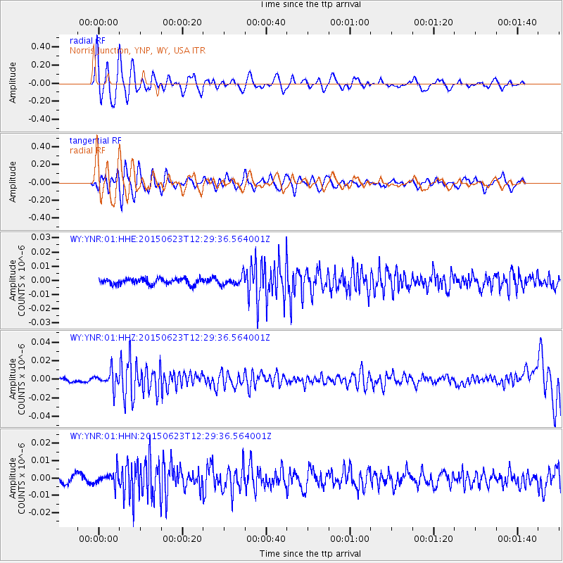
| Radial Match: |
80.815865 % |
| Radial Bump: |
400 |
| Transverse Match: |
60.035034 % |
| Transverse Bump: |
400 |
| SOD ConfigId: |
7422571 |
| Insert Time: |
2019-04-19 10:47:15.922 +0000 |
| GWidth: |
2.5 |
| Max Bumps: |
400 |
| Tol: |
0.001 |
|
Signal To Noise
| Channel | StoN | STA | LTA |
| WY:YNR:01:HHZ:20150623T12:29:36.564001Z | 4.0504184 | 9.182812E-9 | 2.2671265E-9 |
| WY:YNR:01:HHN:20150623T12:29:36.564001Z | 1.8415017 | 3.8139074E-9 | 2.0710855E-9 |
| WY:YNR:01:HHE:20150623T12:29:36.564001Z | 2.7062192 | 5.6142597E-9 | 2.074577E-9 |
| Arrivals |
| Ps | 6.1 SECOND |
| PpPs | 23 SECOND |
| PsPs/PpSs | 29 SECOND |


