You are here: Home > Network List > IU - Global Seismograph Network (GSN - IRIS/USGS) Stations List
> Station HRV Harvard, Massachusetts, USA > Earthquake Result Viewer
HRV Harvard, Massachusetts, USA - Earthquake Result Viewer
| Earthquake location: |
Washington |
| Earthquake latitude/longitude: |
47.1/-122.7 |
| Earthquake time(UTC): |
2001/02/28 (059) 18:54:32 GMT |
| Earthquake Depth: |
52 km |
| Earthquake Magnitude: |
6.5 MB, 6.6 MS, 6.8 MW, 6.7 ME |
| Earthquake Catalog/Contributor: |
WHDF/NEIC |
|
| Network: |
IU Global Seismograph Network (GSN - IRIS/USGS) |
| Station: |
HRV Harvard, Massachusetts, USA |
| Lat/Lon: |
42.51 N/71.56 W |
| Elevation: |
180 m |
|
| Distance: |
36.1 deg |
| Az: |
78.173 deg |
| Baz: |
295.387 deg |
| Ray Param: |
0.07675697 |
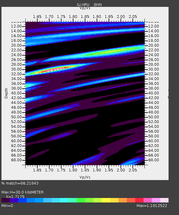
| Estimated Moho Depth: |
30.0 km |
| Estimated Crust Vp/Vs: |
1.72 |
| Assumed Crust Vp: |
6.419 km/s |
| Estimated Crust Vs: |
3.738 km/s |
| Estimated Crust Poisson's Ratio: |
0.24 |
|
| Radial Match: |
86.21843 % |
| Radial Bump: |
387 |
| Transverse Match: |
38.47093 % |
| Transverse Bump: |
400 |
| SOD ConfigId: |
3744 |
| Insert Time: |
2010-03-03 15:07:17.355 +0000 |
| GWidth: |
2.5 |
| Max Bumps: |
400 |
| Tol: |
0.001 |
|
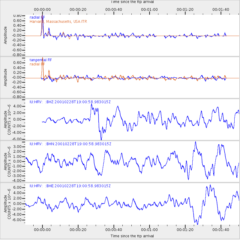
Signal To Noise
| Channel | StoN | STA | LTA |
| IU:HRV: :BHN:20010228T19:00:58.983015Z | 3.0833812 | 1.1689335E-6 | 3.791077E-7 |
| IU:HRV: :BHE:20010228T19:00:58.983015Z | 2.6884346 | 1.0341613E-6 | 3.8467044E-7 |
| IU:HRV: :BHZ:20010228T19:00:58.983015Z | 7.019308 | 3.3669621E-6 | 4.7967154E-7 |
| Arrivals |
| Ps | 3.6 SECOND |
| PpPs | 12 SECOND |
| PsPs/PpSs | 15 SECOND |


