You are here: Home > Network List > IU - Global Seismograph Network (GSN - IRIS/USGS) Stations List
> Station HRV Harvard, Massachusetts, USA > Earthquake Result Viewer
HRV Harvard, Massachusetts, USA - Earthquake Result Viewer
| Earthquake location: |
Near Coast Of Peru |
| Earthquake latitude/longitude: |
-16.1/-74.0 |
| Earthquake time(UTC): |
2001/07/05 (186) 13:53:48 GMT |
| Earthquake Depth: |
62 km |
| Earthquake Magnitude: |
6.2 MB, 6.6 MW, 6.5 ME |
| Earthquake Catalog/Contributor: |
WHDF/NEIC |
|
| Network: |
IU Global Seismograph Network (GSN - IRIS/USGS) |
| Station: |
HRV Harvard, Massachusetts, USA |
| Lat/Lon: |
42.51 N/71.56 W |
| Elevation: |
180 m |
|
| Distance: |
58.3 deg |
| Az: |
2.11 deg |
| Baz: |
182.744 deg |
| Ray Param: |
0.06275067 |
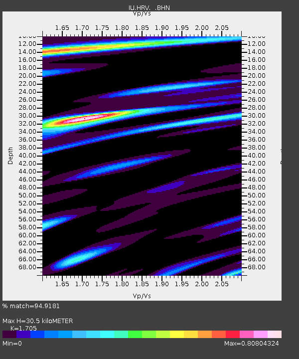
| Estimated Moho Depth: |
30.5 km |
| Estimated Crust Vp/Vs: |
1.71 |
| Assumed Crust Vp: |
6.419 km/s |
| Estimated Crust Vs: |
3.765 km/s |
| Estimated Crust Poisson's Ratio: |
0.24 |
|
| Radial Match: |
94.9181 % |
| Radial Bump: |
364 |
| Transverse Match: |
79.02146 % |
| Transverse Bump: |
400 |
| SOD ConfigId: |
4714 |
| Insert Time: |
2010-03-03 15:07:29.907 +0000 |
| GWidth: |
2.5 |
| Max Bumps: |
400 |
| Tol: |
0.001 |
|
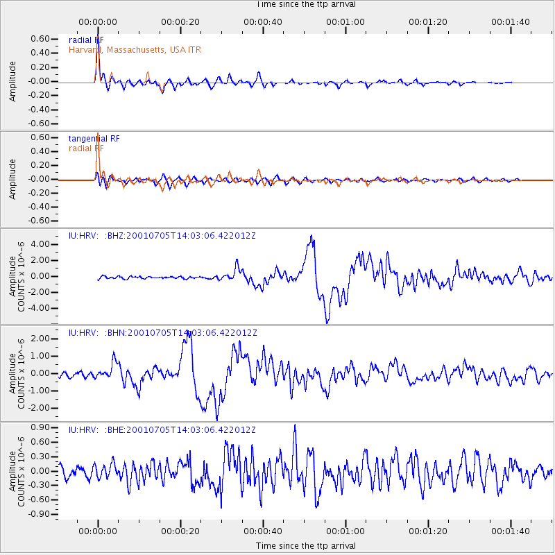
Signal To Noise
| Channel | StoN | STA | LTA |
| IU:HRV: :BHN:20010705T14:03:06.422012Z | 3.4001606 | 4.8822375E-7 | 1.4358845E-7 |
| IU:HRV: :BHE:20010705T14:03:06.422012Z | 1.0100745 | 1.491253E-7 | 1.4763793E-7 |
| IU:HRV: :BHZ:20010705T14:03:06.422012Z | 6.2119446 | 8.0799674E-7 | 1.3007146E-7 |
| Arrivals |
| Ps | 3.5 SECOND |
| PpPs | 12 SECOND |
| PsPs/PpSs | 16 SECOND |


