You are here: Home > Network List > AK - Alaska Regional Network Stations List
> Station RKAV Rock Avalanche, AK, USA > Earthquake Result Viewer
RKAV Rock Avalanche, AK, USA - Earthquake Result Viewer
| Earthquake location: |
Bonin Islands, Japan Region |
| Earthquake latitude/longitude: |
27.7/139.8 |
| Earthquake time(UTC): |
2015/06/23 (174) 12:19:29 GMT |
| Earthquake Depth: |
462 km |
| Earthquake Magnitude: |
5.5 MB |
| Earthquake Catalog/Contributor: |
NEIC PDE/NEIC COMCAT |
|
| Network: |
AK Alaska Regional Network |
| Station: |
RKAV Rock Avalanche, AK, USA |
| Lat/Lon: |
60.30 N/141.35 W |
| Elevation: |
1647 m |
|
| Distance: |
60.9 deg |
| Az: |
34.0 deg |
| Baz: |
275.385 deg |
| Ray Param: |
0.0595317 |
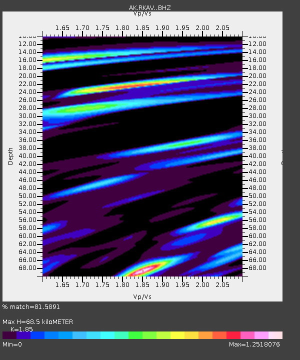
| Estimated Moho Depth: |
68.5 km |
| Estimated Crust Vp/Vs: |
1.85 |
| Assumed Crust Vp: |
6.566 km/s |
| Estimated Crust Vs: |
3.549 km/s |
| Estimated Crust Poisson's Ratio: |
0.29 |
|
| Radial Match: |
81.5891 % |
| Radial Bump: |
400 |
| Transverse Match: |
65.52107 % |
| Transverse Bump: |
400 |
| SOD ConfigId: |
7422571 |
| Insert Time: |
2019-04-19 10:49:39.676 +0000 |
| GWidth: |
2.5 |
| Max Bumps: |
400 |
| Tol: |
0.001 |
|

Signal To Noise
| Channel | StoN | STA | LTA |
| AK:RKAV: :BHZ:20150623T12:28:24.707974Z | 1.1205317 | 3.6051733E-7 | 3.2173773E-7 |
| AK:RKAV: :BHN:20150623T12:28:24.707974Z | 0.64410996 | 2.462819E-7 | 3.8236E-7 |
| AK:RKAV: :BHE:20150623T12:28:24.707974Z | 0.9148368 | 2.8933127E-7 | 3.162654E-7 |
| Arrivals |
| Ps | 9.3 SECOND |
| PpPs | 28 SECOND |
| PsPs/PpSs | 38 SECOND |


