You are here: Home > Network List > IU - Global Seismograph Network (GSN - IRIS/USGS) Stations List
> Station SFJD Sondre Stromfjord, Greenland > Earthquake Result Viewer
SFJD Sondre Stromfjord, Greenland - Earthquake Result Viewer
| Earthquake location: |
Kuril Islands |
| Earthquake latitude/longitude: |
46.0/151.4 |
| Earthquake time(UTC): |
2009/04/18 (108) 19:17:58 GMT |
| Earthquake Depth: |
35 km |
| Earthquake Magnitude: |
6.3 MB, 6.3 MS, 6.6 MW, 6.4 MW |
| Earthquake Catalog/Contributor: |
WHDF/NEIC |
|
| Network: |
IU Global Seismograph Network (GSN - IRIS/USGS) |
| Station: |
SFJD Sondre Stromfjord, Greenland |
| Lat/Lon: |
67.00 N/50.62 W |
| Elevation: |
330 m |
|
| Distance: |
66.1 deg |
| Az: |
9.289 deg |
| Baz: |
343.37 deg |
| Ray Param: |
0.0577997 |
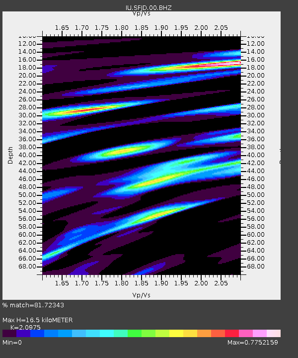
| Estimated Moho Depth: |
16.5 km |
| Estimated Crust Vp/Vs: |
2.10 |
| Assumed Crust Vp: |
6.459 km/s |
| Estimated Crust Vs: |
3.08 km/s |
| Estimated Crust Poisson's Ratio: |
0.35 |
|
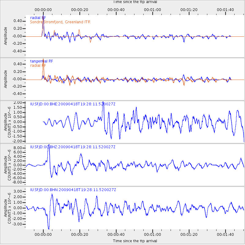
| Radial Match: |
81.72343 % |
| Radial Bump: |
400 |
| Transverse Match: |
67.93027 % |
| Transverse Bump: |
400 |
| SOD ConfigId: |
2760 |
| Insert Time: |
2010-03-03 15:08:10.218 +0000 |
| GWidth: |
2.5 |
| Max Bumps: |
400 |
| Tol: |
0.001 |
|
Signal To Noise
| Channel | StoN | STA | LTA |
| IU:SFJD:00:BHZ:20090418T19:28:11.520027Z | 6.98783 | 4.3121995E-6 | 6.171013E-7 |
| IU:SFJD:00:BHN:20090418T19:28:11.520027Z | 8.100657 | 1.794602E-6 | 2.2153783E-7 |
| IU:SFJD:00:BHE:20090418T19:28:11.520027Z | 2.4210896 | 9.331988E-7 | 3.854458E-7 |
| Arrivals |
| Ps | 2.9 SECOND |
| PpPs | 7.6 SECOND |
| PsPs/PpSs | 11 SECOND |


