You are here: Home > Network List > IU - Global Seismograph Network (GSN - IRIS/USGS) Stations List
> Station SFJD Sondre Stromfjord, Greenland > Earthquake Result Viewer
SFJD Sondre Stromfjord, Greenland - Earthquake Result Viewer
| Earthquake location: |
Montana |
| Earthquake latitude/longitude: |
45.4/-112.6 |
| Earthquake time(UTC): |
2005/07/26 (207) 04:08:37 GMT |
| Earthquake Depth: |
13 km |
| Earthquake Magnitude: |
5.7 MB, 5.2 MS, 5.6 MW, 5.5 MW |
| Earthquake Catalog/Contributor: |
WHDF/NEIC |
|
| Network: |
IU Global Seismograph Network (GSN - IRIS/USGS) |
| Station: |
SFJD Sondre Stromfjord, Greenland |
| Lat/Lon: |
67.00 N/50.62 W |
| Elevation: |
328 m |
|
| Distance: |
38.5 deg |
| Az: |
33.851 deg |
| Baz: |
267.64 deg |
| Ray Param: |
0.075500466 |
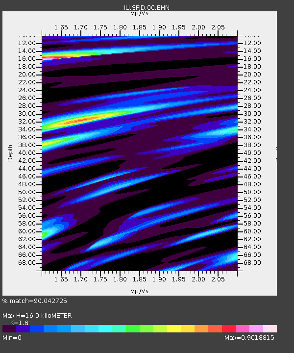
| Estimated Moho Depth: |
16.0 km |
| Estimated Crust Vp/Vs: |
1.60 |
| Assumed Crust Vp: |
6.459 km/s |
| Estimated Crust Vs: |
4.037 km/s |
| Estimated Crust Poisson's Ratio: |
0.18 |
|
| Radial Match: |
90.042725 % |
| Radial Bump: |
320 |
| Transverse Match: |
78.22261 % |
| Transverse Bump: |
400 |
| SOD ConfigId: |
2422 |
| Insert Time: |
2010-03-03 15:08:13.111 +0000 |
| GWidth: |
2.5 |
| Max Bumps: |
400 |
| Tol: |
0.001 |
|
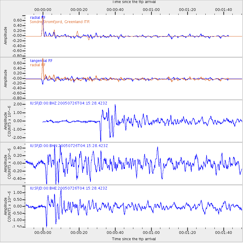
Signal To Noise
| Channel | StoN | STA | LTA |
| IU:SFJD:00:BHN:20050726T04:15:28.423Z | 3.4872725 | 1.848837E-7 | 5.3016706E-8 |
| IU:SFJD:00:BHE:20050726T04:15:28.423Z | 7.5307407 | 4.725553E-7 | 6.2750175E-8 |
| IU:SFJD:00:BHZ:20050726T04:15:28.423Z | 11.906612 | 7.7688696E-7 | 6.5248365E-8 |
| Arrivals |
| Ps | 1.6 SECOND |
| PpPs | 5.9 SECOND |
| PsPs/PpSs | 7.5 SECOND |


