You are here: Home > Network List > AV - Alaska Volcano Observatory Stations List
> Station SPCR Ckakachatna River, Mount Spurr, Alaska > Earthquake Result Viewer
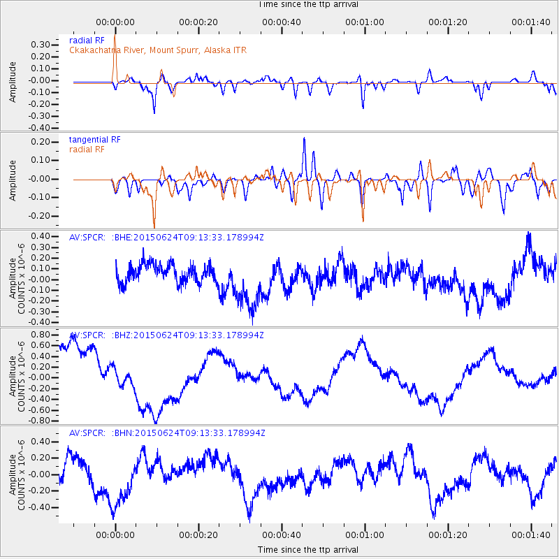
SPCR Ckakachatna River, Mount Spurr, Alaska - Earthquake Result Viewer
*The percent match for this event was below the threshold and hence no stack was calculated.
| Earthquake location: |
South Of Kermadec Islands |
| Earthquake latitude/longitude: |
-32.3/-178.0 |
| Earthquake time(UTC): |
2015/06/24 (175) 09:00:41 GMT |
| Earthquake Depth: |
20 km |
| Earthquake Magnitude: |
5.0 mb, 5.0 mb, 4.2 MS |
| Earthquake Catalog/Contributor: |
ISC/ISC |
|
| Network: |
AV Alaska Volcano Observatory |
| Station: |
SPCR Ckakachatna River, Mount Spurr, Alaska |
| Lat/Lon: |
61.20 N/152.21 W |
| Elevation: |
984 m |
|
| Distance: |
95.5 deg |
| Az: |
12.199 deg |
| Baz: |
201.689 deg |
| Ray Param: |
$rayparam |
*The percent match for this event was below the threshold and hence was not used in the summary stack. |
|
| Radial Match: |
62.218098 % |
| Radial Bump: |
400 |
| Transverse Match: |
65.144264 % |
| Transverse Bump: |
400 |
| SOD ConfigId: |
7422571 |
| Insert Time: |
2019-04-19 11:00:49.868 +0000 |
| GWidth: |
2.5 |
| Max Bumps: |
400 |
| Tol: |
0.001 |
|
Signal To Noise
| Channel | StoN | STA | LTA |
| AV:SPCR: :BHZ:20150624T09:13:33.178994Z | 0.3994077 | 1.8199954E-7 | 4.556736E-7 |
| AV:SPCR: :BHN:20150624T09:13:33.178994Z | 2.6261814 | 3.278034E-7 | 1.2482131E-7 |
| AV:SPCR: :BHE:20150624T09:13:33.178994Z | 3.172875 | 2.679485E-7 | 8.444975E-8 |
| Arrivals |
| Ps | |
| PpPs | |
| PsPs/PpSs | |


