You are here: Home > Network List > IU - Global Seismograph Network (GSN - IRIS/USGS) Stations List
> Station SFJD Sondre Stromfjord, Greenland > Earthquake Result Viewer
SFJD Sondre Stromfjord, Greenland - Earthquake Result Viewer
| Earthquake location: |
Pakistan |
| Earthquake latitude/longitude: |
34.5/73.6 |
| Earthquake time(UTC): |
2005/10/08 (281) 03:50:40 GMT |
| Earthquake Depth: |
26 km |
| Earthquake Magnitude: |
6.9 MB, 7.7 MS, 7.6 MW, 7.3 MW |
| Earthquake Catalog/Contributor: |
WHDF/NEIC |
|
| Network: |
IU Global Seismograph Network (GSN - IRIS/USGS) |
| Station: |
SFJD Sondre Stromfjord, Greenland |
| Lat/Lon: |
67.00 N/50.62 W |
| Elevation: |
328 m |
|
| Distance: |
70.3 deg |
| Az: |
339.808 deg |
| Baz: |
46.467 deg |
| Ray Param: |
0.055018775 |
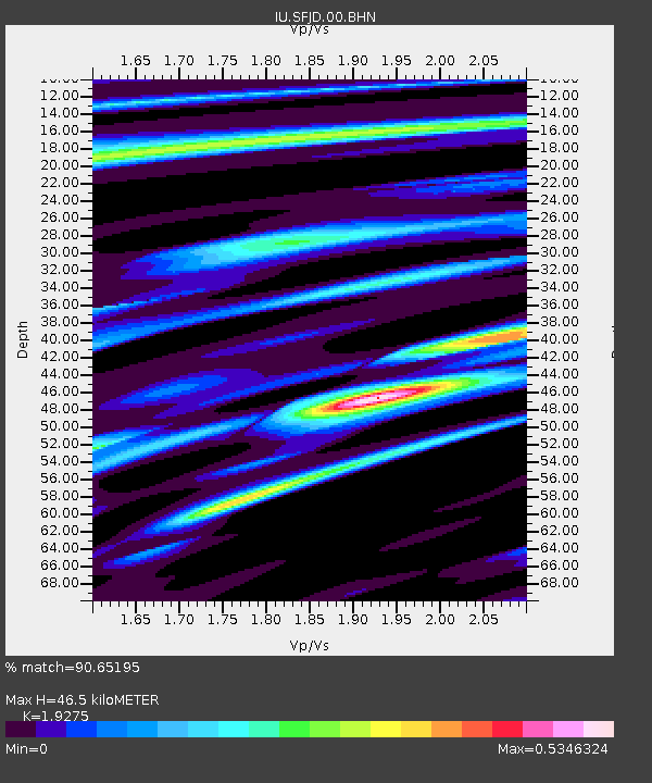
| Estimated Moho Depth: |
46.5 km |
| Estimated Crust Vp/Vs: |
1.93 |
| Assumed Crust Vp: |
6.459 km/s |
| Estimated Crust Vs: |
3.351 km/s |
| Estimated Crust Poisson's Ratio: |
0.32 |
|
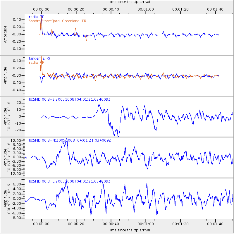
| Radial Match: |
90.65195 % |
| Radial Bump: |
319 |
| Transverse Match: |
81.09331 % |
| Transverse Bump: |
400 |
| SOD ConfigId: |
2475 |
| Insert Time: |
2010-03-03 15:08:18.846 +0000 |
| GWidth: |
2.5 |
| Max Bumps: |
400 |
| Tol: |
0.001 |
|
Signal To Noise
| Channel | StoN | STA | LTA |
| IU:SFJD:00:BHN:20051008T04:01:21.034009Z | 8.17418 | 4.3943623E-6 | 5.375906E-7 |
| IU:SFJD:00:BHE:20051008T04:01:21.034009Z | 2.2198412 | 2.1903445E-6 | 9.867123E-7 |
| IU:SFJD:00:BHZ:20051008T04:01:21.034009Z | 10.338891 | 9.872754E-6 | 9.549142E-7 |
| Arrivals |
| Ps | 6.9 SECOND |
| PpPs | 20 SECOND |
| PsPs/PpSs | 27 SECOND |


