You are here: Home > Network List > WY - Yellowstone Wyoming Seismic Network Stations List
> Station YHH Holmes Hill, YNP, WY, USA > Earthquake Result Viewer
YHH Holmes Hill, YNP, WY, USA - Earthquake Result Viewer
*The percent match for this event was below the threshold and hence no stack was calculated.
| Earthquake location: |
South Of Kermadec Islands |
| Earthquake latitude/longitude: |
-32.3/-178.0 |
| Earthquake time(UTC): |
2015/06/24 (175) 09:00:41 GMT |
| Earthquake Depth: |
20 km |
| Earthquake Magnitude: |
5.0 mb, 5.0 mb, 4.2 MS |
| Earthquake Catalog/Contributor: |
ISC/ISC |
|
| Network: |
WY Yellowstone Wyoming Seismic Network |
| Station: |
YHH Holmes Hill, YNP, WY, USA |
| Lat/Lon: |
44.79 N/110.85 W |
| Elevation: |
2717 m |
|
| Distance: |
98.0 deg |
| Az: |
41.481 deg |
| Baz: |
231.981 deg |
| Ray Param: |
$rayparam |
*The percent match for this event was below the threshold and hence was not used in the summary stack. |
|
| Radial Match: |
63.55791 % |
| Radial Bump: |
341 |
| Transverse Match: |
70.14032 % |
| Transverse Bump: |
400 |
| SOD ConfigId: |
7422571 |
| Insert Time: |
2019-04-19 11:04:08.214 +0000 |
| GWidth: |
2.5 |
| Max Bumps: |
400 |
| Tol: |
0.001 |
|
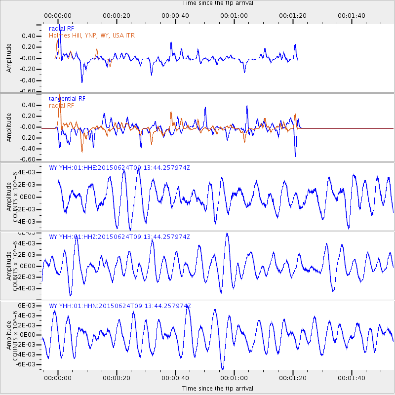
Signal To Noise
| Channel | StoN | STA | LTA |
| WY:YHH:01:HHZ:20150624T09:13:44.257974Z | 0.9331773 | 2.360992E-9 | 2.5300575E-9 |
| WY:YHH:01:HHN:20150624T09:13:44.257974Z | 2.5279272 | 3.0522274E-9 | 1.2074032E-9 |
| WY:YHH:01:HHE:20150624T09:13:44.257974Z | 1.0321555 | 2.231196E-9 | 2.1616857E-9 |
| Arrivals |
| Ps | |
| PpPs | |
| PsPs/PpSs | |


